DRAFT PROPOSAL: THE TWISTNIET FIELD
|
This draft proposal will proceed to Sketch Design stage - once the lease holder, AFRICAN BROTHER'S FOOTBALL ACADEMY PTY (LTD) has approval on the re-zoning application from the City of Cape Town. 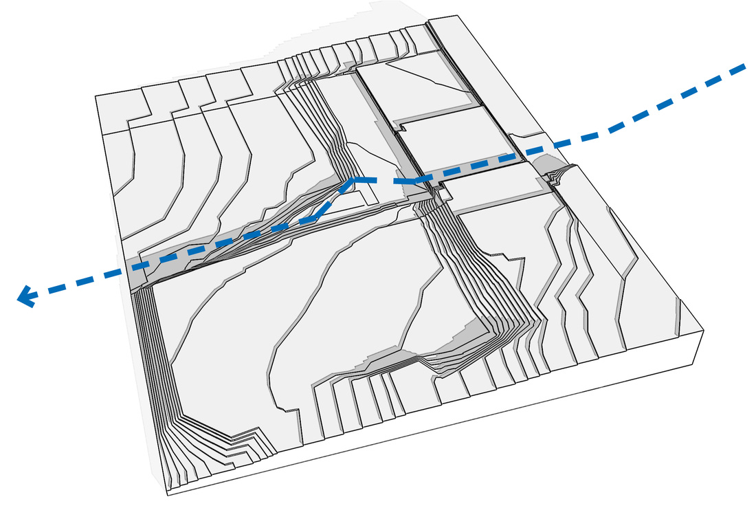
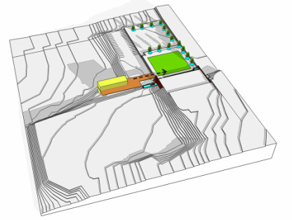
...and a river flows through - Drawing by Y.Tsai of Tsai Design Studio.
Here, you can see a short clip from February 2012, by CNN's Eroll Barnett - "Inside Africa" correspondent, exploring the tunnel, which runs through this site, transporting un-utilised water to the sea.
|
|
A brief history of the old millstream
Soon after the Dutch settled at the Cape, it was found that the City Bowl was too windy to grow grain and other staples. Land in more sheltered situations was sought, for grain
farming (wheat in particular) to the east of the Windberg (Devil’s Peak) on
the deep loamy alluvial soils along the Liesbeek River, further sheltered from the southerly winds, by the
granite spur of the Boscheuvel (Wynberg Hill).
In May 1656, Jan van Riebeeck noted the inhabitants (referred to as Caepmen/Hottentot) of approximately 90 dwellings of straw and grazing lands for some 10-12,000 cattle on the loamy soils of the Liesbeek River, where he cleared an area for a kraal.
(Ref: Bosman DB and Thom HB, Daghregister gehouden by den Opperkoopman Jan Anthonisz van Riebeeck, deel 11:38)
This resulted in the first forced removals in South Africa. And on 20 February 1657, perusing the freeburgher grant, Jan van Riebeeck was approached by Herrij and Gogosa, (representatives of the Caepmen) enquiring as to where they should live since new houses were to be erected where their straw houses stood and their cattle grazed…
By the end of February, two areas had been settled by the free-burghers:
Groenveldt, 5 free-burghers – to plant wheat.
Hollandsen Thuyn, 4 free-burghers – to plant wheat, vegetables, fruit, and tobacco - later, to breed cattle, pigs and poultry.
The freeburghers were not productive farmers and shortly after settlement, their properties became inns. This resulted in the first zoning laws at the Cape, when it was stipulated that only 20 inns were permitted long the Liesbeek River.
(Ref: Bosman DB and Thom HB, Daghregister gehouden by den Opperkoopman Jan Anthonisz van Riebeeck, deel 11:38)
The free-burghers would ride their produce into town, along the old Wagenpad and would camp out in what is today, De Waal Park on Camp Street - from where they had easy access to many mills along the old mill stream.
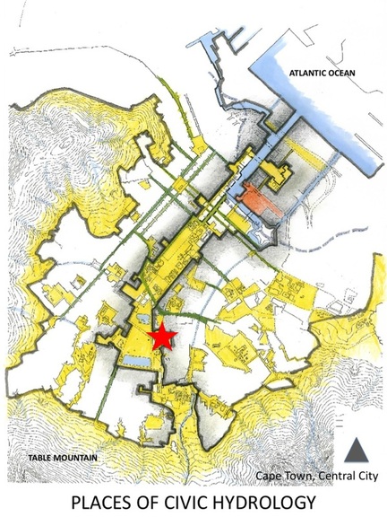
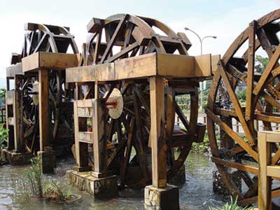
The mills stood between De Grendel on Table Mountain and the south end of the VOC Company’s Garden, along CAMISSA. One was a wind mill; two were steam mills - the others were all driven by water. Water turned the cogs of industry in old Cape Town.
Here, is a photo essay on some of the mills along the old mill stream.
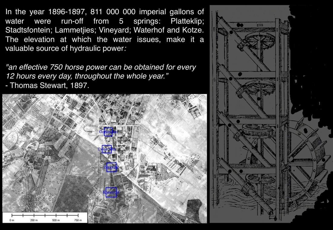
The VOC imported a corn mill, to be worked by horses. As most of the animals were stolen, it was decided to make use of the Fresh (Vaarsche) River as a source of motive power. In 1657, a mill was situated on the site of todays, Cape Town High School. The woodwork of the mill was rotten by 1664 and so another was erected in 1685, behind the Company’s Garden. In the 1830 census, it was recorded that there were six functional mills at the foot of Table Mountain. The mills stood between the town and the mountain, the water was led into the mills in wooden pipes raised on wooden supports.
In addition to the water mills along the old millstream, the Gortmolen and Twistniet Mills also had steam-mills and in 1856, a windmill was erected between Twistniet and Zorgvliet Mills.
In May 1656, Jan van Riebeeck noted the inhabitants (referred to as Caepmen/Hottentot) of approximately 90 dwellings of straw and grazing lands for some 10-12,000 cattle on the loamy soils of the Liesbeek River, where he cleared an area for a kraal.
(Ref: Bosman DB and Thom HB, Daghregister gehouden by den Opperkoopman Jan Anthonisz van Riebeeck, deel 11:38)
This resulted in the first forced removals in South Africa. And on 20 February 1657, perusing the freeburgher grant, Jan van Riebeeck was approached by Herrij and Gogosa, (representatives of the Caepmen) enquiring as to where they should live since new houses were to be erected where their straw houses stood and their cattle grazed…
By the end of February, two areas had been settled by the free-burghers:
Groenveldt, 5 free-burghers – to plant wheat.
Hollandsen Thuyn, 4 free-burghers – to plant wheat, vegetables, fruit, and tobacco - later, to breed cattle, pigs and poultry.
The freeburghers were not productive farmers and shortly after settlement, their properties became inns. This resulted in the first zoning laws at the Cape, when it was stipulated that only 20 inns were permitted long the Liesbeek River.
(Ref: Bosman DB and Thom HB, Daghregister gehouden by den Opperkoopman Jan Anthonisz van Riebeeck, deel 11:38)
The free-burghers would ride their produce into town, along the old Wagenpad and would camp out in what is today, De Waal Park on Camp Street - from where they had easy access to many mills along the old mill stream.
The mills stood between De Grendel on Table Mountain and the south end of the VOC Company’s Garden, along CAMISSA. One was a wind mill; two were steam mills - the others were all driven by water. Water turned the cogs of industry in old Cape Town.
Here, is a photo essay on some of the mills along the old mill stream.
The VOC imported a corn mill, to be worked by horses. As most of the animals were stolen, it was decided to make use of the Fresh (Vaarsche) River as a source of motive power. In 1657, a mill was situated on the site of todays, Cape Town High School. The woodwork of the mill was rotten by 1664 and so another was erected in 1685, behind the Company’s Garden. In the 1830 census, it was recorded that there were six functional mills at the foot of Table Mountain. The mills stood between the town and the mountain, the water was led into the mills in wooden pipes raised on wooden supports.
In addition to the water mills along the old millstream, the Gortmolen and Twistniet Mills also had steam-mills and in 1856, a windmill was erected between Twistniet and Zorgvliet Mills.
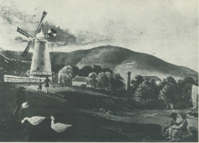
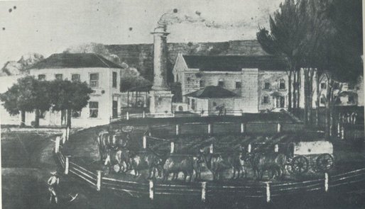
Thomas Sutherland's Windmill, Upper Orange Street, Gardens, Cape Town. The Millstream bed in the foreground. Twistniet Mill (steam mill's chimney stack) on the right. Artist and date unknown, but after 1856.
Cape Archives AG 14300
REF: The Story of Milling and Brewing at the Cape of Good Hope, Edited by James Walton, Collector's Press (Pty) Ltd, CT, 1978, pp.11
|
Twistniet Mills, which incorporated a water mill and a steam mill.
Date and artist, unknown.
Cape Archives AG 14301
|
THE WATER MILLS ALONG THE OLD MILLSTREAM
Water was used not only for replenishing the depleted supplies of ships en-route to the East Indies, but also for irrigating fresh produce vital for the health of the crews, for providing a domestic supply for the newly established community and to provide power to drive mills. The mill was so important that a placcaat was issued:
"Everyone shall be expressly beware of stopping the watercourses in this Table Valley, or leading the water away to their land, no matter in what manner or with what pretence such may be done, on pain of six rix reals for each offence, as the mill and other affairs are impeded in consequence.”
HOPE MILL (a corn mill), was erected in 1685.
THE GORTMOLEN (a barley mill) was erected in 1741 and stood at the corner of St. Quinton’s Road - once, a deep ravine of the old millstream; and Mill/Annandale Street. The mill continued to function until the early 1900s and was only demolished in the 1960s - its site is today occupied by the De Waal Hotel and the Lennox Residential Hotel.
RHEEZICHT MILL (a corn mill) was erected in 1783 on the corner of Belmont and Rosemount Avenues and still functioned in the early 1900s.
PLATTEKLIP MILL (a groats mill) was erected in 1793. The first miller was Hendrik Lange, who operated it until 1812. In 1826, the miller was Johannes Bernadus Engelbrecht, who sold it to Joshua Andries Joubert in 1828, who let it to Francis Russel Brett, who was probably the miller in the painting by Otto Landsberg, according to James Walton. The miller who owned it from 1834, was Petrus Johannes de Wet, who used to grind wheat, barley and also curry spices, which earned him the name of 'Kerriekruie' (curry spice) De Wet. The mill has been converted into 2 semi-detached Edwardian cottages; and is used by the Forestry and Waterworks Departments of the City of Cape Town.
TWISTNIET MILL, was comprised of two large mills one erected in 1801, the other in 1808, between the Gortmolen and the Rheezicht Mills. These were demolished in the early 1900s. The site of these mills today encompasses a large playing field - off Upper Orange Street, and disconnected from the old river, but the pattern of the landscape can still be read in the old oak trees that once lined the river banks. There exists a vast amount of wasted / lost space in the form of disused tennis courts which had fallen into disrepair. AFRICAN BROTHER'S FOOTBALL ACADEMY PTY (LTD) have had a lease on the land and improvements have occurred.
ZORGVLIET MILL was on the corner of Prince and Sir George Grey Streets - opposite the Zorgvliet Farmstead and the Hurling swaai pump. The exact date of its erection is not known, but it was already in existence from 1825, when Michiel van Breda was listed as the miller, and owner of the garden and house at Zorgvliet. In 1848, Jacob Letterstedt (and his wife) were the registered owners of the Prince Street Mill. In 1857, James Smith was the miller at Letterstedt's Mill, in Prince Street. Of cultural interest here, since the street is named after George William Prince (died 1858), who took also took possession of the Gortmolen in 1855. In 1867, Zorgvliet Mill was owned by H.O.A. Truter, with Willian Cox and H. Groenewald as the millers. And in 1869, the mill was sold to W. Silberbauer, who also owned the Platteklip, Rheezicht and Annnandale Mills at this time. It was converted into a house and later demolished, in the 1950s.
Discussion document for the draft proposal
|
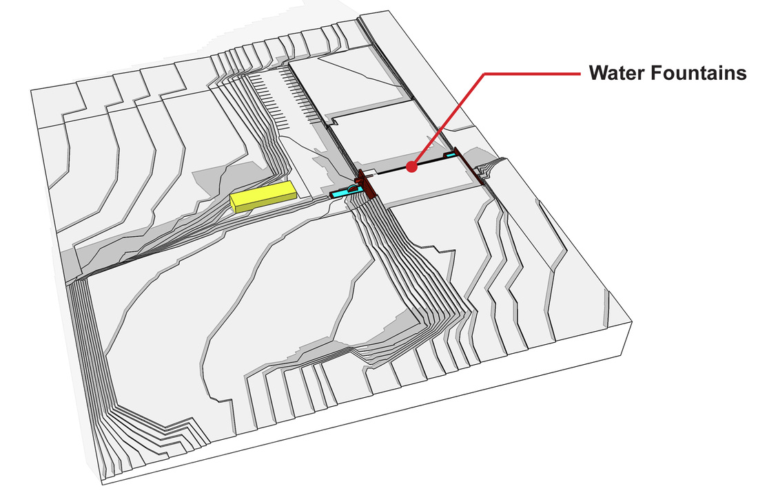
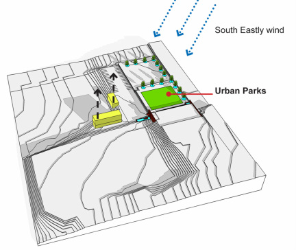
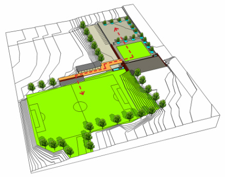
NEW INTERVENTIONS
Activate CAMISSA (Water & Heritage)
|
|
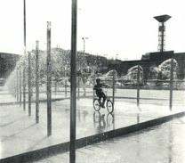
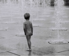
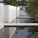
PRECEDENT: INTER-ACTIVE WATER PLAY
|

|
|
|
NEW INTERVENTIONS
New Urban Parks (Community Spaces)
|
|
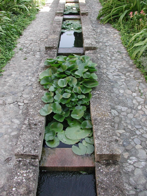
PRECEDENT: INTERPLAY OF FUNCTION & AESTHETICS
|

|
|
|
|
NEW INTERVENTIONS
New Bridge
|
|
|
NEW INTERVENTIONS
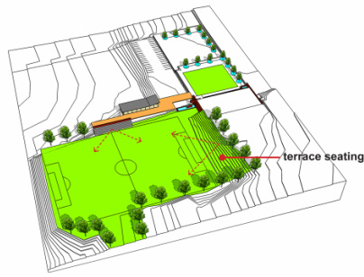
New grandstand & terraced seating
|
|
|
NEW INTERVENTIONS
Upgraded sports field
A connected site within the precinct & to the broader context
|
|
|
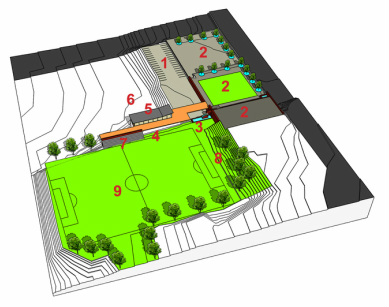
1. parking. 2. urban parks. 3. water wheel, fountains and other water features to include interactive water play. 4. clubhouse - change rooms. 5. clubhouse - restaurant/tea room & pavillion. 6. future extensions - natural swimming pool / reservoir. 7. grandstand seating. 8. terraced seating & picnic spots. 9. football field. |
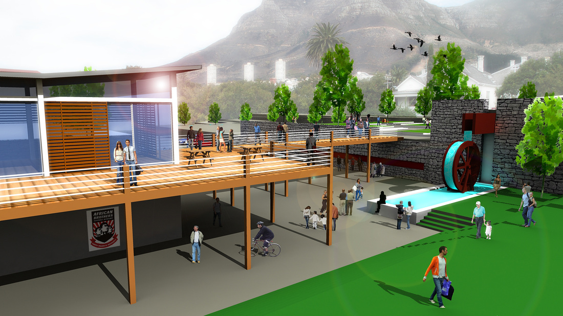
TWISTNIET FIELD: Memory Wall; Water wheel; Clubhouse; Bridge to Urban Park; upgraded fields. Drawing by Y.Tsai of Tsai Design Studio, 2011.
RECLAIM CAMISSA in association with
|


|

|

|

|
|

|
ALL RIGHTS ARE RESERVED by THE RECLAIM CAMISSA TRUST No. IT 2882/2010.
This is a citizen-scientist open source database. By acknowledging and referencing the source, you are welcome to use the material and information provided here for the common good.
This is a citizen-scientist open source database. By acknowledging and referencing the source, you are welcome to use the material and information provided here for the common good.
