RECLAIM CAMISSA
Contact us
  • HOME
  • BLOG
  • MEDIA

BLOG

CAMISSA 'the place of sweet waters', is the Khoi name for Cape Town. Embedded, lost and obscured within the city's fabric this vital ecological and cultural link still exists....

RECLAIM CAMISSA FACEBOOK PAGE

Water – our Heritage and our Future...

24/9/2018

1 Comment

 
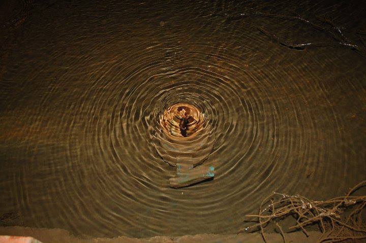
"No man ever steps in the same river twice,
For it's not the same river and he's not the same man"
 

- Heraclitus, Ancient Greek Philosopher.
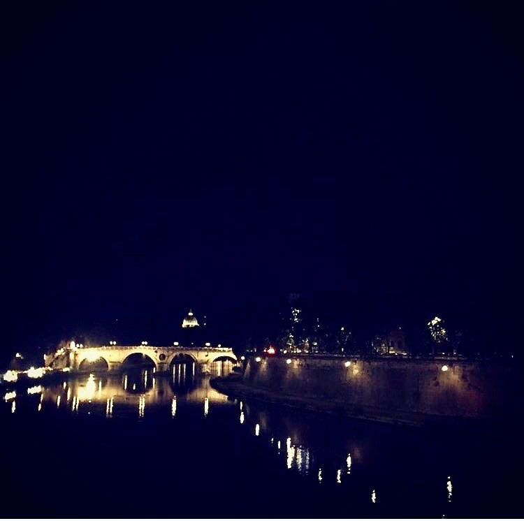
Heritage Day in Cape Town, nestled below Table Mountain, one of the globe’s most iconic images, with the rugged, flat top of the mountain contrasting with the soft table-cloth-cloud spilling over its edges, make it a living monument to the forces that shape it - wind and Water. 
​
Picture
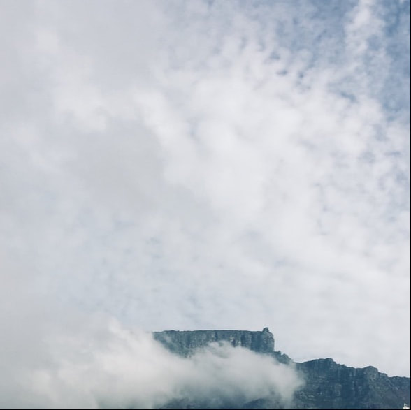
Photo credit: Caron von Zeil, 2018.
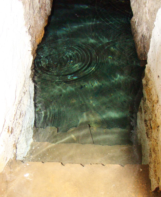
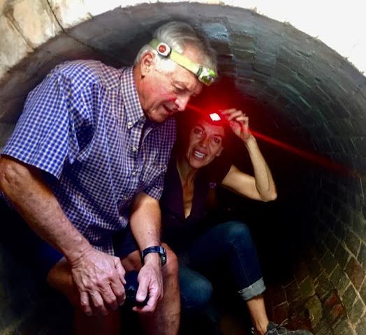
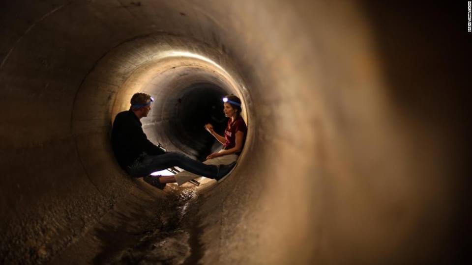
Water, key to understanding and appreciating the natural history of the Table Valley together with the stories of this Water flowing off the mountain, links the natural to the political and cultural landscapes of the city. The Camissa Water system flows between two World Heritage sites: Table Mountain and Robben Island, and is an authentic illustration of the evolution of the Earth and the origin of life, 3 500million years ago to the present. It is an interactive ecology that reveals a tense relationship between humankind, land and Water - at the frontier of our modern nation. It is a unique system of ecological and historical significance - a cultural landscape - the manifestation of centuries of interaction between people and their natural environment.

The streams that run from the mountain brought the Khoekhoen here every spring for up to 1500 years before colonial settlement. The springs and streams that flow through the dry summer were the key to farming the land. Water drove the wheels of industry and quenched the thirst of beasts, residents and passing sailors. Until well into the 1900s, the principal economic base for Cape Town, was to supply passing ships, and Water was central to making that feasible. 
​
Picture
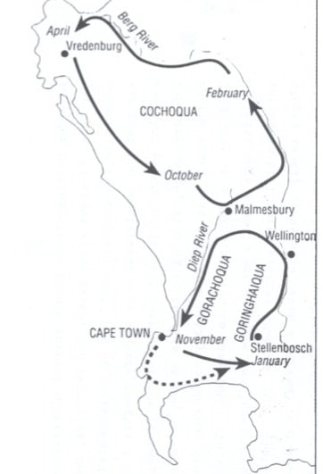
Map of the annual Khoi transhumance patterns in and around the Cape Peninsula.
Image source: From Andrew Smith, in “The Making of a City”, by Worden, et al.
​The unique stories surrounding the sweet waters that flow from a series of artesian springs beneath the iconic Table Mountain are... 
‘a symbol of the many trials and tribulations that accompanied the displacement of first nation users, the disparity in society that arises when the privileged are given preferential access, and the subsequent abuse of a resource to the point of collapse.’ - Dr. Anthony Turton. 
 
The story of Table Mountain’s Water is the story of power, of forgotten voices, of people displaced, of slavery and of slavery overturned. It is the story of Water harnessed as well as wasted. As we follow this Water, back and forth in time, we uncover many interwoven stories, alternating between moments of technological ingenuity, stupidity, enlightenment, and barbarism. Throughout, there are the profound links between the past, the present and the future. 
Picture
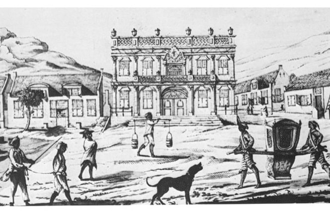
Slave Water carriers on Greenmarket Square.
Image: Cape Archives M166: BURGHERSWACHTPLEIN (1764).


The waters of Table Mountain were both revered and defiled, at times the source of well-being and and at other times a carrier of life-threatening diseases, such as the Smallpox epidemic of 1713. At different points along the water’s course, mills were built and power was generated from the flow. The mills stood between the town and the mountain, the Water was led into the mills in wooden pipes raised on wooden supports. In the 1830 census, it was recorded that there were six functional mills at the foot of Table Mountain. 

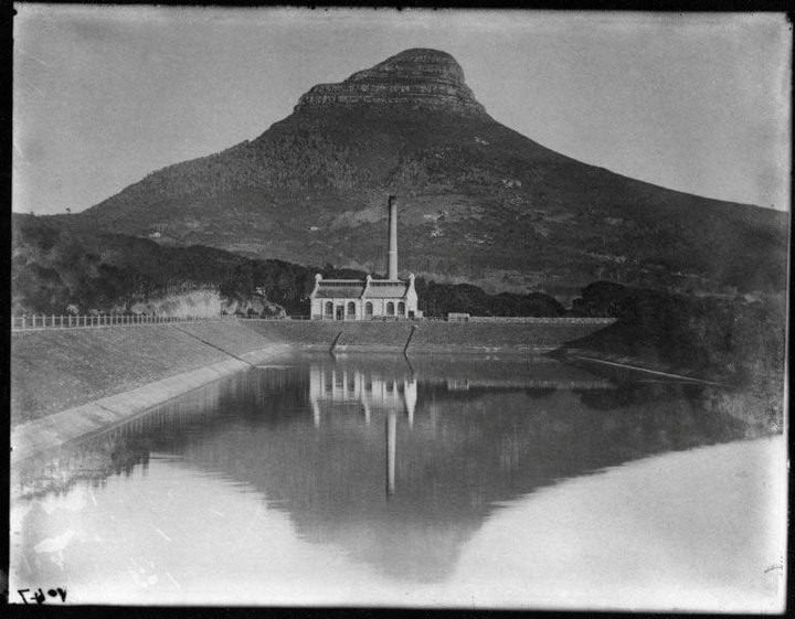
Cape Town, a colonial backwater, an outpost of relative insignificance in the British Empire, utilised its Water to generate electricity for its street lighting, while London still relied on gas lamps.  Initially, Cape Town had been supplied with gaslight. This changed when a small electric lighting station was established at the western end of the Molteno Reservoir.

The German firm of Siemens and Hulske supplied the power plant and in 1894 began laying the first underground cables. In 1895, the Graaff Hydro-Powered Electric Lighting Station of the Cape Town Corporation was officially inaugurated as the generating station of the lighting installation. The structure still stands today as a fine example of early industrial architecture, but no longer serves this function and is falling into disrepair. 

Picture
The Graaff Hydro-Powered Electric Lighting Station
There is much to be learnt from the past as we confront the challenges of climate change, such as Water shortages, rising sea levels and storms. The stories of Water in Cape Town are rich in texture, redolent with memories, myths and cultural practices. These stories are evocative and add to our understanding of life as it has been lived on the southern tip of the African continent. 
The way streams were channelled down and across valleys, gave the form to land holdings and is the essence of the spatial geometry of Cape Town. The early streets ran parallel and at right angles to the streams that flowed from the mountain to the sea. Later, these streams were formalized and directed into ‘grachte’ (canals). 

For example the Heerengracht – today’s Adderley Street, was the first principal street of the settlement, one of 4 rivers that the Dutch named the Varsche River. It was threaded by a double streamlet, with tiny bridges crossing at intervals and ran through the town centre providing the continuity of the axis of the Company’s Garden linked by way of an old gateway, lined with stoeped townhouses of the burghers and at its foot was the wooden jetty. By 1767 the street had been widened into a fashionable promenade. It was described by a traveller in 1778 as “the most beautiful street or canal, bordered with oaks, along which are built the finest houses.”
Picture
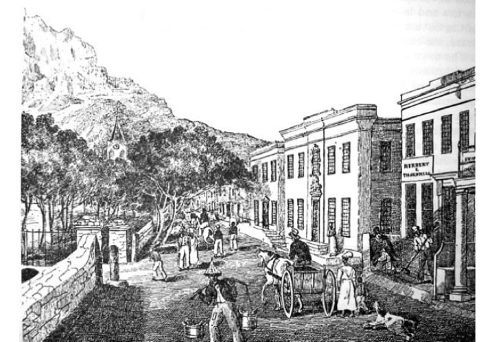
HEERENGRACHT - what is today ADDERLEY STREET, circa 1832.
In the Platterklip Stream, what was once a riverbed is now a clearing in the trees, where a circle of rocks lie. This is where the slaves (and later the Washerwomen) took the population’s laundry. ​Here lies a gem of our cultural history...
Picture
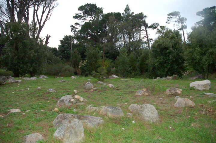
Cape tradition was that the slaves took the population’s laundry to Platteklip. After the emancipation of the slaves (1 December 1834), their descendants continued to launder at Platteklip and at Capel Sluit, and to hold the 'place' as sacred.

“Every afternoon when the weather was warm the old washer-women would offload their bundles of washing at the corner of the Old Homestead at Oranjezicht. One of the sights of Table Mountain was the long procession of Malay washer-women, huge bundles on their heads, swinging along up Hope and Buitenkant Streets and along the Slave Walk. (Today’s Gorge Road) For many years they used the stream and rocks provided by nature, to be scoured and bleached. Almost daily more than 100 slaves could be seen, busy with the family washing. 

After the abolition of slavery, there was a celebration along Platteklip on the first of December each year. The washer-women would clutter up the mountain in their ‘kaperrangs’ (clogs). Early in the afternoon they would leave their washing and dance waltzes to improvised music. Then, as twilight began to creep through the pines, they would march with their bundles down the path by the crumbling slaves walls of the
Oranjezicht
and Rheezicht estates.” 

On one such occasion, an attractive Malay girl, the wife of an Hafiz, named Abdul Malik, lost the ring her husband sometimes let her wear, while washing clothes at Platteklip Gorge. She and her friends searched high and low along the banks, but the ring was never found again...... 

The ring had been given to Abdul by a great scholar in Mecca under whom Abdul studied Islam. The aged scholar considered him to be his best scholar; and besides bestowing much love upon him, gave him a ring which he was always to wear on his finger. The significance of the ring was never understood, until one day when he went to have his head shaved according to Islamic rule. The barber found that the razor would not cut. After attempts with a second razor had also failed, someone in the shop suggested that Abdul might be wearing a charm, guaranteed to prevent his being harmed by a knife. Puzzled, Abdul removed the ring and experienced no difficulty being shaved. On occasions, the Hafiz’s wife found that when she was wearing the ring, she was unable to cut bread and anything with a blade seemed to be magically turned away when brought near her. 

The ring was lost. The search was fruitless. Tradition says that the Hafiz’s magic ring will be found again, one day.”
--In Joe Lison, unpublished manuscript "From Rivulets to Reservoirs", 1970:38-39. 
A ring was found in 2006, by an American scholar - Dr. Elizabeth Grzymala-Jordan, on this site. The dig revealed plentiful artefacts - enough to fill 34 apple boxes. Dr. Grzymala-Jordan's work looked at slavery globally, and in particular at the role of women slaves. More specifically, the work she did in Cape Town, is recorded in a document submitted as part of her DPhil in Anthropology: "FROM TIME IMMEMORIAL: Washerwomen, Culture, and Community in Cape Town, South Africa", January 2006 - submitted to the Graduate School New Brunswick, State University of New Jersey.
Picture
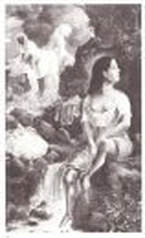
'Washerwomen on Table Mountain' - an oil painting by Otto Landsberg circa 1880, reproduced in 'Otto Landsberg 1803-1905', by Simon A. De Villiers.
Picture
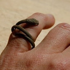
One of two rings uncovered in the archaeological dig conducted along the Platteklip Stream, by Dr. Elizabeth Grzymala-Jordan, in 2006. 
Robert Ernest Bryson (born 1867, Glasgow) was a composer who wrote symphonies. In 1926 he composed an opera: "The Leper’s Flute", with words by Ian Colvin. The story is set at the site of the Platteklip Waterfall and washing pools. A copy of the opera can be found here.
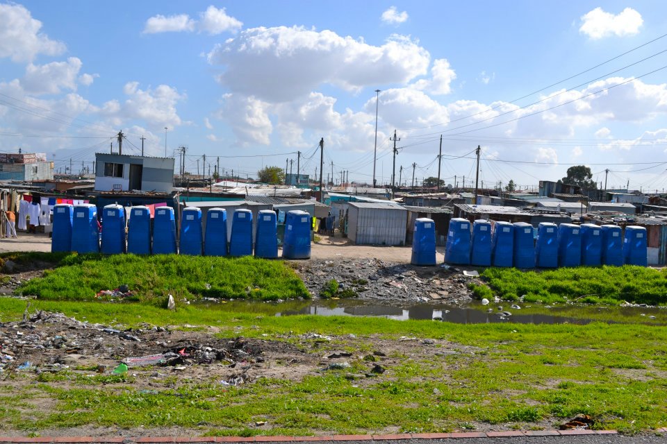
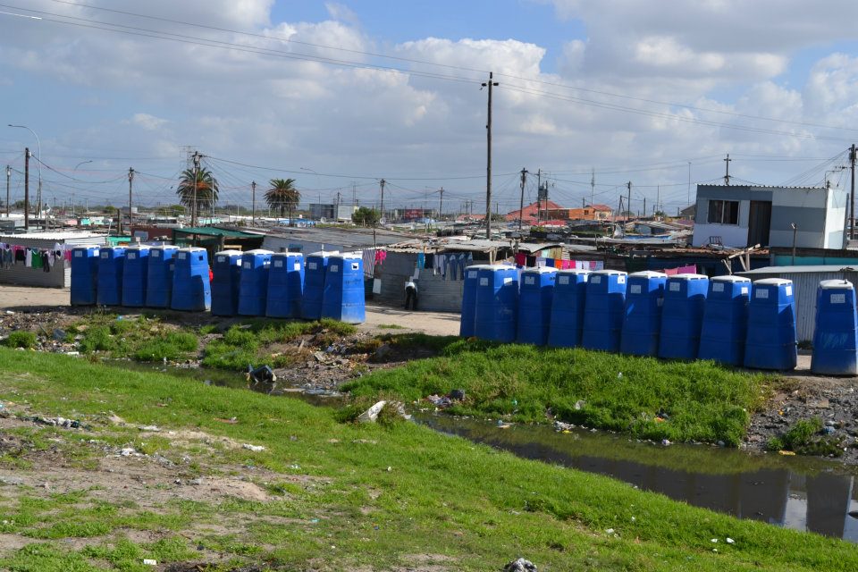
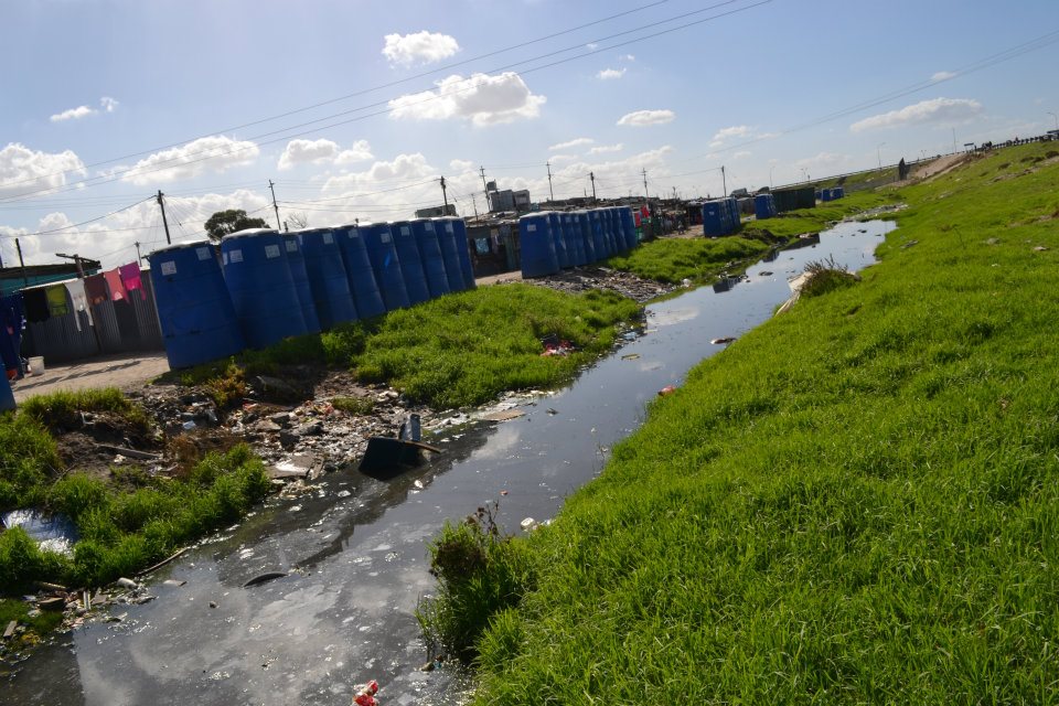
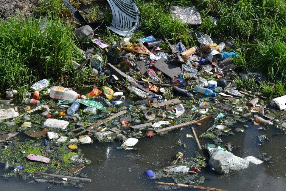
WATER POLLUTED
 
A poem by Willian Bridekirk, published in May 1825, describes:
“Canals, thro’ some of the streets flow.
Which stink confoundly you must know;
And serve so handy for lazy wenches, 
To cast therein their slop-pail stenches.
Some sluts, besides the above named slop, 
Other burdens have been known to drop
Into these reservoirs of pollution”.
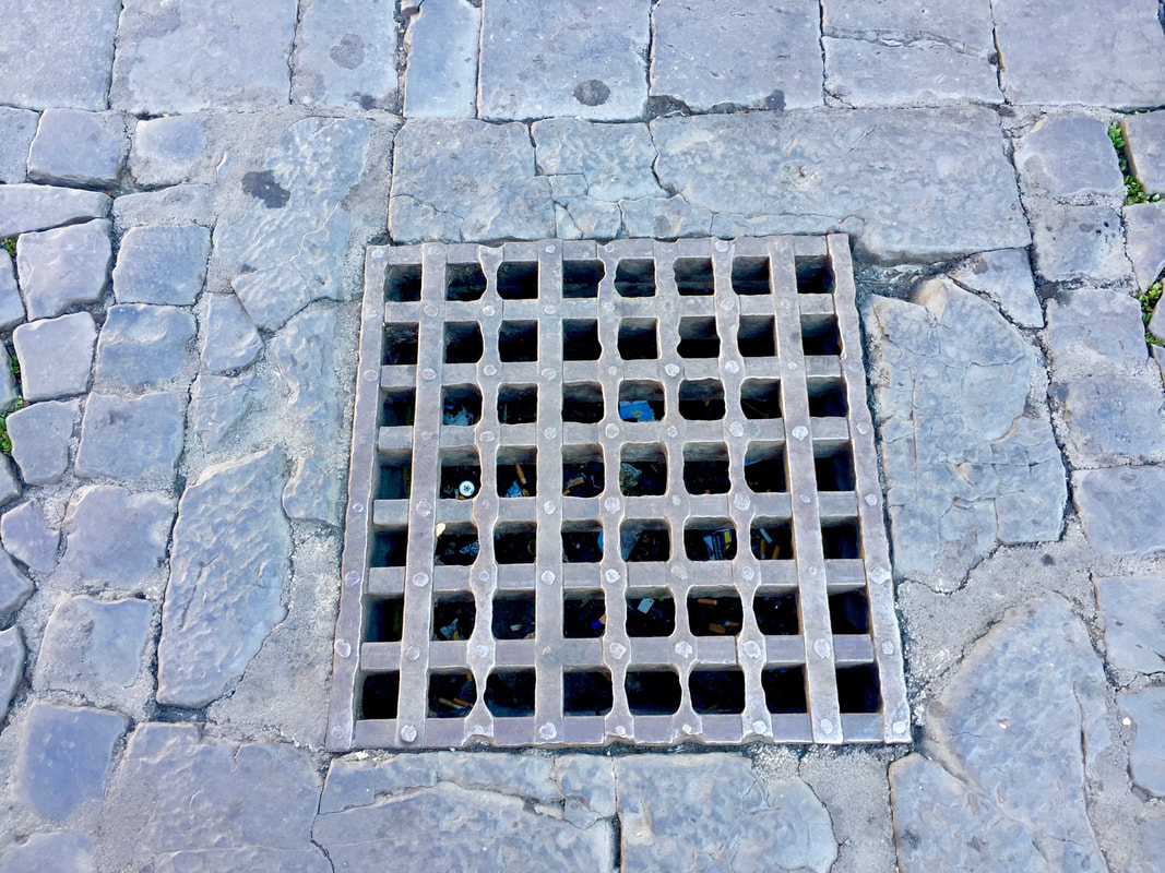
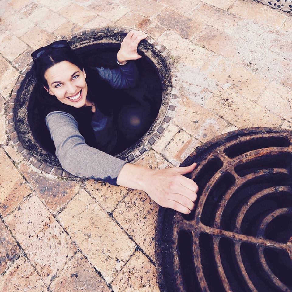
The ‘grachte’ had become the dumping place for the town’s rubbish. By the time the Bubonic Plague hit Cape Town, Water was forced underground and became redundant, making its way to the sea via sewers and stormwater channels. 

A systematic programme of arching over and enclosing the canals was initiated in 1838, directly changing the character of old Cape Town. At first a number of bridges were built over the canals and some canals paved. Eventually the majority of the grachte had been replaced by brick sewers. By the end of the 1860s, the last stretch of the Heerengracht had been covered and the street, renamed Adderley Street. In 1901, the last of the open Water courses was closed, in District Six. 
Picture
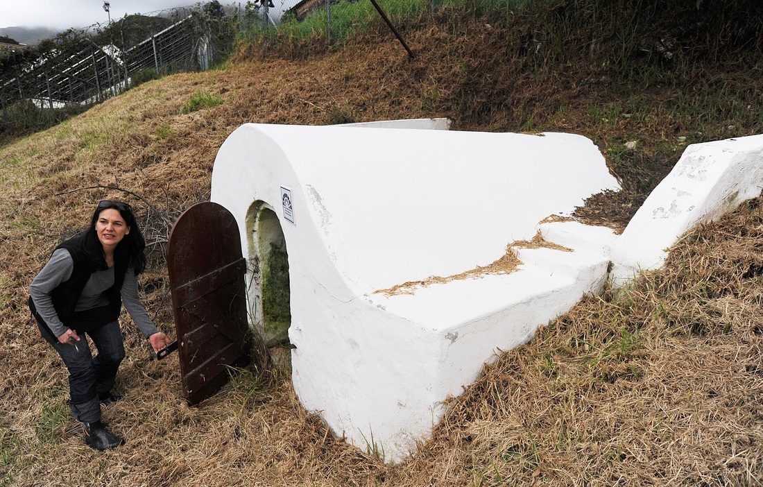
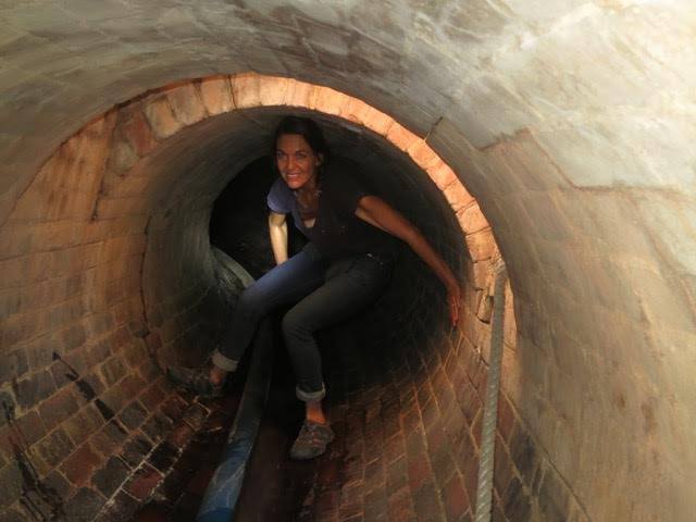
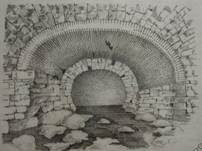
WALE STREET GRACHT. Image source: H.P.B. Rigby, in 'Report on the Stormwater Drainage', The Corporation of the City of Cape Town, April 1898.
Picture
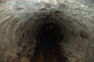
BUITENKANT STREET GRACHT/TUNNEL. Photo credit: Caron von Zeil, 2010.
WATER LINKS PAST, PRESENT AND FUTURE

The Golden Acre Shopping Mall was constructed on the original shoreline, the previous frontier between the city and the sea, at the very spot where the colonialists and slaves disembarked. In the 1970s excavations revealed the earliest dam and sluice that was built to supply the passing trade.

Picture
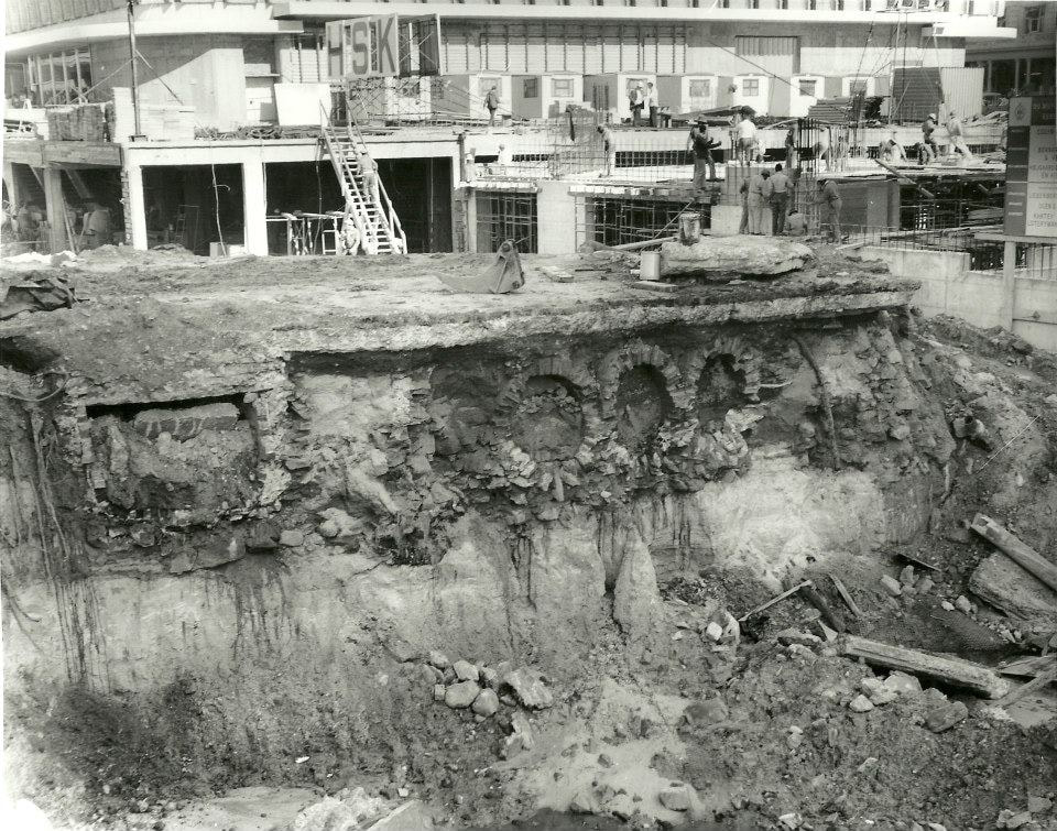
Subterranean sluice channels uncovered during the building of the Golden Acre shopping mall, c. 1973/4.
Excavations of the Cape Town train station forecourt for the FIFA 2010 Football World Cup, revealed the timber from the original old wooden jetty of the early 1600s; an old ship's anchor and a British well, which was quickly and deliberately covered. 

The missed opportunity to reveal the ancient entrance to the city by sea faring nations where South Africa’s colonists and slave ancestors landed, represented a closing of a frontier at a time when so many eyes were focused on the city. In the rush to complete construction before the FIFA 2010 Football World Cup, the site was backfilled and covered over. In the words of Archaeologist, Dr. Antonia Malan: "It was here that sea voyagers stepped ashore - whether freely or not, healthy or sick or dying - it was the umbilical cord that sustained passing ships with fresh food and water - and conducted vital supplies to the struggling settlement - from where indigenous and foreign exiles and convicts were offloaded and shipped to Robben Island - where famous and infamous travellers disembarked.”
​Journeying through the ‘lost spaces’ associated with Cape Town’s waterways, a global story of Water, land and humankind unfolds. When one uncovers the history of a 'place', it is through means of title deeds - ownership and power, however, when one uncovers the history of a 'place', through its Water - one uncovers the popular history of that place. As one follows the path of these waters from mountain to ocean, the fact that Water follows the path of least resistance and has no boundaries, is revealed. 
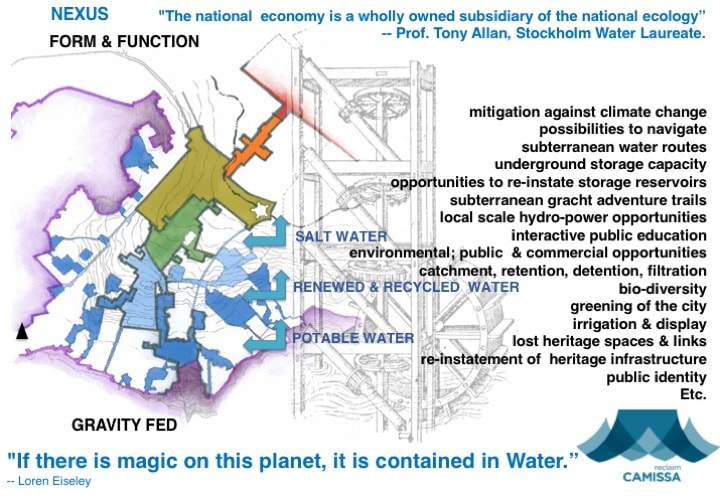
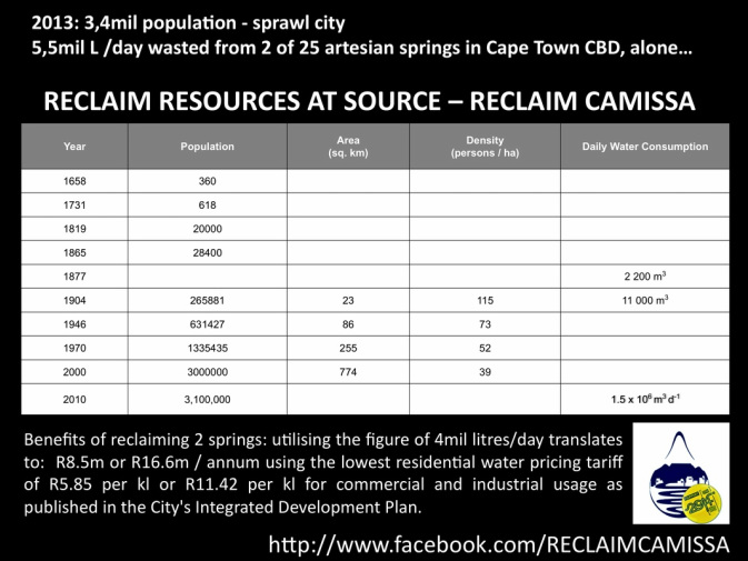
CAMISSA is a (hydro-spatial) development framework, which through the use of Water, focuses on the re-instatement of the socio-ecological link that reunites the mountain and the sea, into a public landscape - as a sustainable solution for Cape Town's CBD.

This framework is comprised of a series of systematic structural maps for the integration of natural and urban layers of the city. It is a system that re-structures the city according to environmental principles and establishes integrated and flexible urban development around the natural resource of Water. Thus, enabling us to rise and meet future environmental challenges in a city no longer Water secure. The vision is one of a Water Sensitive City and a genuinely progressive Water management strategy that offers opportunities for new models to transform the future wellbeing of the city into an equal society for all people; whilst allowing for public integration and education through the recreational use of the system. 
 ​
Picture
​
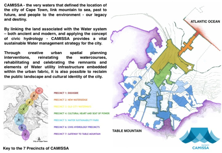
What is evident, after much research and analysis is that there are seven distinct areas within this  catchment that reflect the fundamental reason for the city's establishment - the ways in which Water occurs, previously functioned; and could potentially function in the future - if environmental principles are applied; and if we are to reclaim and use the Water resources and their associated land parcels - to the benefit of the city and her inhabitants, optimally.

These "precincts" have been defined after spatially mapping the geographical area from the perspective of 'a city within its region'; and this local area within its metropolitan context - in accordance with its natural and urban systems; and then overlayed with a series of maps that examine how the city functions on a temporal and spatial basis, throughout the different seasons of Winter, Spring, Summer and Autumn - day or night.
 
The seven precincts (more like the French term “quartier”) are geographical areas, which unlock the potential to design a sequence of projects, which can be rolled out systematically; and which capture the full range of historical, cultural, social and ecological heritage; and provide economic, educational and place-making potentials associated with the city's Water resource - in a holistic, integrated and co-ordinated manner.  

Today, Cape Town is Water challenged: chronic shortages coupled with extreme Water pollution. Restrictions on Water usage are currently legislated. Tomorrow will bring the additional realities of climate change: rising sea levels and periods of alternating flooding and drought. Water-related issues are a priority, not only because future economic growth relies on adequate provision of Water that will sustain development for present and future generations – but life itself. 
 
Many of the sites encompassed in these precincts are testimony to our primal need for Water, to the interaction between our predecessors and our interaction with the Earth, and our imperative need to co-exist respectfully and harmoniously with nature. It is thus crucial that they are protected that we may benefit from them in the future. As the environmental crisis escalates worldwide, urgent and thoughtful steps need to be taken to reduce Water loss, waste and pollution. Strengthened community awareness and participation, collaborative approaches and an empowered citizenry are evermore essential - to rekindle our profound connection and respect for Water.

Picture
Legacy and Destiny
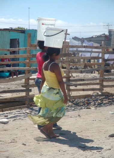
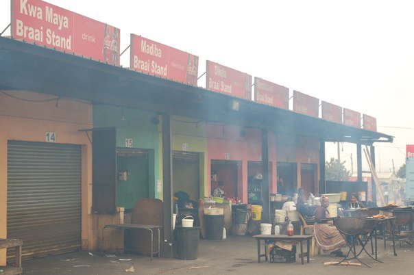
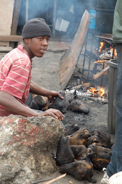
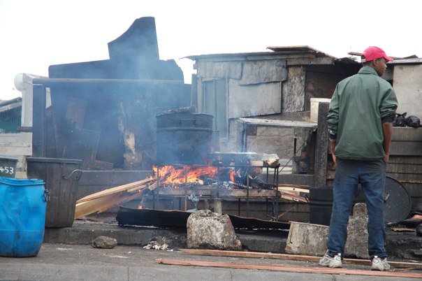
Water carriers , Indlovini, Monwabisi - Cape Town.
​Photo credit: Caron von Zeil.
So, perhaps on this Heritage Day, you may wish to contemplate our ecological and social heritage, and take a stroll along CAMISSA with this guided map  - although it is much in need of an update.
ALL RIGHTS ARE RESERVED by THE RECLAIM CAMISSA TRUST No. IT 2882/2010.
This is a citizen-scientist open source database. By acknowledging and referencing the source, you are welcome to use the material and information provided here for the common good.
All research, spatial framework and proposals are the intellectual property of Caron von Zeil. ​
1 Comment

A cultural landscape of fountains and the human right of access to clean Water...

31/7/2018

2 Comments

 
Almost twenty years ago, whilst living in Seattle, Washington in the United States, I stumbled across a publication that profoundly changed the course of my life. The publication plagued my thoughts a year later, when stranded with my (then one year old) son and our beloved Ela, bella - a travelling dog, in an idyllic village at the foot of the Sierra Madre del Sur mountains on the coast of Oaxaca, Mexico - with no access to Water.
Picture
The Fisherman's Chapel, San Agostinillo, Oaxaca - Mexico, 2001.
Once a week, a 400-500mm concrete pipe spewed pee-soup green Water for irrigation into the village of about 70 inhabitants who occupied mostly informal or temporary structures, made of natural materials. The smell was so bad on those days, that the inhabitants would leave the village and taxi the 40 minutes ride, to the town of Potchutla for shopping. Despite being born in the Namib Desert, nothing had equipped me for such a rude awakening - life without access to (clean) Water. 

Together with the womenfolk of the village,  I washed my son's diapers in a nearby river, as the idea of using bottled mineral Water to do that task did not bode well. Water to drink, cook, wash and bathe was supplied by a truck that would service the coastal villages three times a day, delivering 25l casks of mineral Water. The familiar call of "Aaaaa-gua-aaa" was always welcome, as I attempted to keep the three of us clean, healthy and hydrated. 
The publication was ARCADE, Volume 19.1, Fall 2000, and there were four articles in it: ‘Hydroscape / Cityscape’, by Katherine Rinne; ‘Civic Hydrology’, by Kathy Poole ; 'Istanbul - Queen of Cities', by Henry Matthews; and 'Steelhead - Streams and Stormwater: securing the urban greenfrastructure', by Michael Houck - that changed the way I  consider resources, the design of infrastructure, and cities.

On returning to South Africa sometime later, and realising that architectural practice was reserved mainly for the elite, and no longer aligned with my longing to serve the collective, nor did it provide a wholistic system of design to better serve planet, place and people - I embarked on a master's degree during which time I became fascinated by the work of Katherine Wentworth Rinne,
 “THE WATERS OF THE CITY OF ROME”:  “Aquae Urbis Romae”
Picture
Screenshot of the interactive map and timeline: “THE WATERS OF THE CITY OF ROME” - Katherine Rinne

​As the website states, it ‘is an interactive cartographic history of the relationships between hydrological and hydraulic systems and their impact on the urban development of Rome, Italy…it examines the intersections between natural  systems - springs, rain, streams, marshes, and the Tiber River - and constructed systems including aqueducts, fountains, sewers, bridges, conduits, etc., that together create the Water infrastructure of Rome’. 

​
The study begins in 753 BC and is intended to extend to the present day; it aims to increase understanding of the profound relationships that exist between Water systems, cultural practice, and the urban development of Rome, and by its example - all cities, landscapes, and environments. 
Picture
The Tiber River, by day - July 2018.
​

Picture
The Tiber River, by night - July 2018.
​

Rinne’s intention, that the study would ‘foster work by other scholars and designers interested in exploring the ways in which Water infrastructure can be exploited toward the future development of humane, ecologically responsible, and engaging civic environments; all are important factors as today we face both critical Water shortages and rising sea levels due to climate change’ - has certainly been achieved, as I continue to be fascinated by the Roman system, and its endless provision of precedent ideas for cities, globally.

It is highly recommended, that students of Hydrology, Civil Engineering, Architecture, Landscape Architecture, Urban Design and Planning explore this interactive map and timeline. The study of a 2800 year old manmade infrastructure, which reflects a cultural landscape may influence your thinking about how to better implement design strategies for Water infrastructure, that would positively influence the landscapes of our future cities.
​
Picture
Trevi Fountain - standing 26.3 metres high and 49.15 metres wide, is the largest Baroque fountain in Rome and one of the most famous fountains in the world. (July, 2018)
Trevi Fountain - July 2018.
As Katherine Rinne concluded in that publication from so many Moons ago, 
“Love for our waters should go hand in hand with love of our cities and towns. As we attempt to remediate past wrongs to our environment we must also keep in mind that there is no one right answer, and even the best answer is part of a process. Our goal is to encourage a new level of urban analysis and appreciation, based on an acknowledgement of where and how we live in our watershed, and of the impact that hydrological forces, processes and technology have on the development of a city. By examining any town or city through its Water infrastructure, we will all gain a richer understanding of urban dynamics. Furthermore, as designers and planners we will be able to ground our theoretical and design work more fully in the real context of the city, and as citizens will be able to see our urban environment as a network of linked forces, which in turn will bring a deeper understanding of the specific features of individual neighbourhoods and places”.
​
Roman Water Supply - how Roman Engineers kept Water flowing for miles around the expansive metropolis, ‘fountains that today, are still safe to drink from’: 

Roman Engineering – Aqueducts:
​Roman aqueducts, that supplied Water all over the Roman Empire and served as a mechanism for control, as the Romans could cut the supply off at any moment in time:
On a recent trip to Rome, I was once again reminded of the Arcade publication and Rinne’s interactive map, as I explored the city with my daughter and witnessed the fundamental human right of access to clean Water - a right implemented in the city, through a multitude of icy-cold free-flowing drinking fountains. 
Picture
A free-flowing drinking fountain, in the Jewish Quarter of Rome - July, 2018. 
"Rome is one of the few cities in the world with a dual Water system - one that has been in use for more than 2,300 years. Supplied chiefly by aqueducts, the city retains the best Water (from springs in the Apennine Mountains) for drinking, and uses second-class Water (from the volcanic Bracciano Lake) for industrial and non-potable uses including fountain displays. Additionally, the Water flowing into the city rarely serves only one purpose before flushing the sewers."
"Continuously overflowing Water from public fountains is redirected through gravity to other non-potable fountains or used to irrigate public gardens. Additionally Roman Water law has always fostered wide public use. Until recently public fountains were used for drinking, cooking, bathing, tending animals and doing laundry and consequently were considered of primary importance. Public Water was "free" and plentiful, while private Water users (in palaces, villas, and industries) paid steep rates for the privilege of piped Water. Even today when everyone has Water at home, public fountains are still considered essential to daily life and the efficient functioning of the city". - Katherine Rinne in "Hydroscape / Cityscape" - ARCADE, Volume 19.1, Fall 2000, pp. 25.
Some free-flowing drinking fountains from which we drank and collected Water, as witness to the implementation of the human right of access to (clean) Water - every Roman’s right.
Picture
Picture
Water infrastructure in Rome - July, 2018.
Such cultural landscapes are a legacy for every person as the great diversity of the interactions between humans and their environment are revealed. Living traditional cultures are protected and the traces of those which have disappeared - are preserved, and in this way, 'a sense of place' or identity for future generations is created. The potential benefits from such preservation are enormous, as these special places remind us of the aspects of a country's origins and development, reveal much about humankind's evolving relationship with the natural world and provide scenic, economic, ecological, social, recreational and educational opportunities that help individuals, communities and nations understand themselves, serving as texts and narratives of a culture in relationship with their ecological contexts over time.
​
Some of the many splendid fountains of Rome, that through their form and features reveal much about the Roman’s evolving relationship with the natural world. Additionally, a substantial source of revenue for the city - approximately 1million Euros worth of coins, is gathered from Roman fountains annually.
July, 2018.
In Rome, I was reminded, that by celebrating Water as a civic infrastructure, Cape Town’s hidden hydro-structure - a system of 32 springs supplying four streams, forced underground into a warren of engineered tunnels, a reclaimed and encroaching coastline; and bountiful unused heritage utility infrastructure - a cultural landscape is reflected.  That recovering this past, illustrates Water as part of city life, culture, religion, work, play, ritual and connectedness and that restored sources that re-integrate Water with urban life, the stories of sharing, healing and celebration are revealed. And that the preservation of the range of heritage; ecosystem types and biodiversity - reinforces the ideal of ‘the commons’ and protects a city’s civic identity.

​Furthermore, that ‘by maintaining the connectivity of the urban-water-continuum citizens are able to understand their own place in reflection to the territory of the city’, which provides a sense of identity and belonging – vital to the functioning of a healthy society.  
Picture
Myself, at the Fontana del Nettuno (Neptune with his trident is accompanied by two dolphins) on Piazza del Popolo - July, 2018.
Picture
Marble pebbles, tossed and tumbled for eons, embody the history of Rome and the spirit of the place - July, 2018.
The design of Camissa, as a hydro-spatial framework was much influenced by the precedent of Rome - to be a hydrological network that could restructure the city according to environmental principles and allow Water to function throughout the public realm as a progressive living system, based on the intrinsic value of Water as a significant public resource, where people can gather around our common heritage, Camissa - the very Waters that defined the location of the city, reflecting the public past and embracing a new civic infrastructure. One, inspired by the deliberate recognition and respect for the cultural and ecological significance of this Water - giving meaning to the ancient name of the city, 'the place of sweet waters'. 
It remains my dream, that one day Table Mountain’s springs will supply drinking Water at historical and cultural locations - throughout the Greater Cape Town Municipal Area, that mark significant places and time in our history.
ALL RIGHTS ARE RESERVED by THE RECLAIM CAMISSA TRUST No. IT 2882/2010.
This is a citizen-scientist open source database. By acknowledging and referencing the source, you are welcome to use the material and information provided here for the common good.
All research, spatial framework and proposals are the intellectual property of Caron von Zeil. ​
2 Comments

Water Security and the Camissa Springs

27/11/2014

1 Comment

 
This blogpost, first published in 2014, has since been added to, to include issues around Water and Urbanisation; Water Security; and groundwater - given the Water crisis facing Cape Town. 
​It is a long, but hopefully informative post. 

Picture
Photo by Coco van Oppens. Stadtsfontein Spring.
“A spring flowing out of the ground appears new. 
We call it a source of fresh water 
Yet the Water is ancient, 
having circulated between Earth and sky for eons...” 


--World Resources Institute, 2002

 ​'every drop counts'

WATER & URBANISATION

More than 50% of the world's population currently live in areas, occupying 2% of the world’s land surface, and consuming 75% of natural resources. As the world becomes increasingly urbanised, there comes a host of challenges. Experts believe that by 2030, 90% of urban growth, will occur in developing countries, with 80% of the global urban population in the towns and cities of Africa, Asia and Latin America. It is said, that 62% of Africa will be urbanised. (GWP)

This unprecedented rate of urban growth represents a unique opportunity to build more sustainable, innovative and equitable towns and cities. Without expanding on the urban environmental discourse, let us agree that 'Cities are well-placed to play a major role in decoupling economic development from resource use and environmental impacts, while finding a better balance between social, environmental and economic objectives. And that resource-efficient cities combine greater productivity and innovation with lower costs and reduced environmental impacts, offering at the same time financial savings and increased sustainability.'
"Cities are human creations and so are shaped according to the principles and approaches that our societies are founded upon. In order to build more resource-efficient cities, a change to global thinking on urbanisation is needed." 
-- Achim Steiner, Executive Director, UNEP 2013.
It becomes apparent that at a global level, Integrated Water Resource Management (IWRM) is fundamental to the global development agenda. Integrated Urban Water Resource Management (IUWM) requires a complex integration of disciplines and scales of function, in order for a city to be Water secure in the future, but what is Cape Town doing to ensure that the crucial link to Water security is achieved within the focus areas of climate change, food security, urbanisation, energy, ecosystems and population growth? 

Precedent for solutions is already well on its way...
"By 2030, Africa’s urban population will double, and the difficulties African cities currently face in providing sustainable Water services will be exacerbated". "The Future of Water in African Cities: Why Waste Water?" argues that the traditional approach of one source, one system, and one discharge cannot close the Water gap. A more integrated, sustainable, and flexible approach, which takes into account new concepts such as 'Water fit to a purpose', is needed in African cities. This study provides examples of cities in Africa and beyond that have already implemented Integrated Urban Water Resource Management (IUWM) approaches both in terms of technical and institutional solutions."

WHAT IS WATER SECURITY?

"The capacity of a population to safeguard sustainable access to adequate quantities of acceptable quality Water for sustaining livelihoods, human well-being, and socio-economic development, for ensuring protection against Water-borne pollution and Water-related disasters, and for preserving ecosystems in a climate of peace and political stability." --UN-Water, 2013.

"80% of the world's population faces high-level Water security or Water-related bio-diversity risk". - Karen Bakker, 2012.
Global Water Statistics
According to the UN-Water Analytical Brief on Water Security and the Global Water Agenda, 2013 'Water security encapsulates complex and interconnected challenges, and highlights Water’s centrality for achieving a larger sense of security, sustainability, development and human well-being. Many factors contribute to Water security, ranging from biophysical to infrastructural, institutional, political, social and financial matters – many of which lie outside the Water realm. In this respect, Water security lies at the centre of many security areas, each of which is intricately linked to Water. Addressing this goal therefore requires interdisciplinary collaboration across sectors, communities and political borders'.

--The United Nations University: "Water Security and the Global Water Agenda", 2013.

In the article by Karen Bakker: "Water Security: Research Challenges and Opportunities", Water security is defined as an “acceptable level of Water-related risks to humans and ecosystems, coupled with the availability of Water of sufficient quantity and quality to support livelihoods, national security, human health, and ecosystem services”. The author highlights the main challenge of balancing human and environmental needs, whilst protecting essential ecosystem services and biodiversity - as problems, largely due to a lack of
i) conceptual common ground for effective Water management and policy-making across disciplines and sectors;
ii) sufficient interdisciplinary collaboration and institutional incentives; and
iii) a discipline and/or scale mismatch - i.e. where certain disciplines focus on different scales, for example hydrologists focus on the catchment (watershed), but politicians focus on the nation.


The Global Water Partnership (GWP) launched a new 2014 - 2019 global strategy towards a Water secure world, which was developed through a year-long process of regional dialogues and consultations with their growing network of over 2,900 partner organizations across 172 countries. The strategy "Towards 2020" stresses the need for "innovative and multi-sectoral approaches to adequately address the manifold threats and opportunities relating to sustainable Water resource management in the context of climate change, rapid urbanisation, and growing inequalities”.

WATER SECURITY IN CAPE TOWN

Water security is a major constraining factor in the future economic growth of Cape Town; and the South Western Cape in particular is critically exposed to Water scarcity issues within the next decade. In 2017 severe restrictions commenced, as demand was soon to outstrip supply, during 2018 - some say 2019, now.  

SUPPLY AND DEMAND - QUANTITY
Cape Town’s Water supply is mostly pumped and piped from the food growing region - from mountain rivers and streams in the surrounding Drakenstein and Franschhoek mountains. The primary source comes from Theewaterskloof Dam, supplemented by Steenbras upper and lower dams; Wemmershoek Dam; Voelvlei Dam; Berg River Dam - which make up 20% of the supply; and the five Table Mountain dams, including Woodhead Dam. http://www.capetown.gov.za/en/Pages/CapeTownsWaterSupplyBoosted.aspx
Weekly Dam Levels
Cape Town's Water supply system is a complex, inter-linked system of dams; pipelines; tunnels and distribution networks. Some elements of the system are owned and operated by the Department of Water Affairs and Forestry and some by the City of Cape Town. According to the City of Cape Town's Water Services Directorate, it is "the largest vertically integrated Water utility in South Africa, serving the largest number of connections (approximately 590 000 formal erven and approximately 100 000 informal sites), with a total annual consumption of potable Water of approximately 300million Kls; and annual wastewater treatment - close to 193million Kls." 

Future developments of the Cape Town Water Supply indicate "that demand in the area served by the system will exceed supply by 2019, and possibly even earlier if Water availability diminishes because of climate change and if Water conservation measures in Cape Town should not be as successful as envisaged. A number of additions to the system, such as the heightening of dams, are considered as well as seawater desalination in order to cope with the rising demand." -- as published by the City of Cape Town, in 2014. 

However, bulk supply is not the answer, and given the lessons learned during the Californian drought, and other climate change impacts on cities - 20th Century infrastructure is not going to suffice during the 21st Century. Diverse, de-centralised solutions are suggested, and this starts with the mapping and monitoring of our sources: stormwater management, sewage recycling, rainwater harvesting, fog harvesting, groundwater (aquifer) protection, recharge and usage, rivers, streams, vleis, beaches, etc. It is necessary that we examine our city within its regional hydro-spatial capacity, and observe the principle:

"WATER FIRST", due to Water’s centrality for achieving a larger sense of security, sustainability, and human well-being, when considering any development. 

The need is to -
1)  research, map and define our Watersheds; 
2)  design Metropolitan scale Hydro-Spatial Frameworks, accordingly;
3)  design Hydro-Spatial Development Frameworks at the Sub-Metropolitan scale; 
4)  to establish Catchment Agencies; and
5) to establish Community Water Stewardship Councils - in this way affect Behavioural Change and Social Transformation, as
"when the source of Water is local, known and honoured culturally, people understand the importance of Water to their health and thus, they care for this source." -- Betsy Damon, Keepers of the Waters.
 
NON-REVENUE WATER
Research by the Water Research Commission indicates that nationally, 36.8% of potable Water destined for urban areas has been lost over the past six years due to leaks; failing infrastructure; and poor financial controls by local authorities - amongst other reasons. This amounts to 1 580 million cubic metres of Water a year, valued at R11billion. According to Xanthea Limberg of the CoCT, Cape Town has an average loss of 17%, which is not bad considering that a 'World Class City', would average around 12%. Whilst measures are being introduced to reduce this loss, it would seem that what is largely being ignored, is the obvious - to satisfy Water needs closer to source, i.e. within geographic proximity of consumption; together with better management of such catchment areas, thereby reducing infrastructural expansion and maintenance. 

However, it would seem that expert advice and strategy pertaining to groundwater or green-frasture and/or eco-system services is ignored. CoCT: Water Services Development Plan, WSDP 2012-2013. 

The problem in the Western Cape, is one of HYDROCIDE - a term coined by Jan Lundqvist (1998), meaning simply when a society suffers as a result of the social misuse of their Water resources. 
      
“that area of land,
a bounded hydrologic system,
within which all living things
are inextricably linked
by their common Water course
and where, as humans settled,
simple logic demanded that

they become part of a community
” --John Wesley Powell

Cape Town requires to make the shift towards a Water Sensitive City: "A city in which Water is managed with regard for its rural origins, coastal destinations and social/cultural significance becomes a Water Sensitive City. A philosophy of flexibility in supply and use to meet all users’ needs underpins the collection and movement of Water, and the technologies to facilitate the physical movement of Water are designs that manifest these ideals visually for all to acknowledge and appreciate." - UNESCO-IHE 

GROUNDWATER  - A SUSTAINABLE RESOURCE, IF PROTECTED

Picture
Waterhof Spring, on the slopes of Table Mountain. Photo credit: Caron von Zeil.
"What makes the desert beautiful is that somewhere it hides a well." --Antoine de Saint-Exupery 

There is approximately one hundred times more groundwater on Earth than fresh surface Water; and given the current environmental issues - climate change, Water and food scarcity - the protection of groundwater is vital. 

"Why is groundwater so important? First, it’s generally a more reliable source of Water than surface Water, which is naturally protected from contamination. Second, groundwater acts as a natural buffer from drought, helping to smooth out rainfall patterns, thereby increasing resilience to climate change. Finally, it can generally be found close to the point of demand. It’s for these reasons and more that groundwater is the main source of Water in low-income countries." 
International Water Management Institute (IWMI) 

In "Unsustainable use of groundwater may threaten global food security", by Karen Villholth, Aditya Sood, and Evgeniya Anisimova, the authors point out that "groundwater constitutes 30% of all liquid freshwater on Earth" the importance of implementing measures to protect groundwater resources are thus evident.
GROUNDWATER 

 
CAMISSA - THE CITY BOWL SPRINGS (TABLE VALLEY CATCHMENT AREA) 
The occurrence of springs along the slopes of Table Mountain are due to the exposure of the contact zone between the porous Sandstone and the impermeable Granite.
According to archival records there are thirty-six artesian springs in the City Bowl of Cape Town.  Thirty-two have been located, of which only thirteen are listed by the municipality. Data regarding the flow dynamics - both quantitative and qualitative, have not been adequately recorded or monitored, since the late 1890s.

In 2015, an updated "Springs Strategy Report" was released. Given the current #WaterCrisis and having obtained two expert reviews of the document, we are of the opinion, that the report and strategy requires a review by an interdisciplinary team of experts. 
 
This Water was not until recently utilised within the municipal Water supply; nor does the Water benefit the ecological system to support the city's biodiversity. Since August 2017, it seems that chlorinators have been installed along the walls of Molteno Reservoir, that appear to be filtering a portion of the supply - as can be seen in this video by Gerhard Söhnge. According to a letter by the Honourable Mayor, Patricia de Lille in the newspapers, 2million litres from the Stadtsfontein was diverted to Molteno Reservoir on 8 November 2017. 
Picture
Stadtsfontein, photo credit: Caron von Zeil.
As a source of potable Water - groundwater plays an increasingly important role;  and given the quantity available within the study area  (almost 6million litres/day on a 3200m site) - the response by RECLAIM CAMISSA to a proposal for the ORANJEZICHT CONSERVATION MANAGEMENT PLAN (OCMP) is pertinent: 

As part of a transparent public process of decision-making and aligned with our mandate 'to provide a stewardship for the waters that flow from Table Mountain to the Atlantic Ocean, that will reclaim Cape Town’s central city connection to the Water - ensuring that the public is able to enjoy the right to this Water; and that the Water remain in good ecological health' - we provide the following concerns, rationale and recommendations regarding the OCMP. 
CONCERNS & RATIONALE
As the unseen nature of groundwater poses a daunting challenge in its quantity and quality - in order to secure the resource for optimal future use, it requires measures for protection, conservation and management that acknowledge the source as inseparable from its associated land; and contextual importance within its hydrological system, and the broader hydrological cycle. 

Whilst in agreement that an incremental approach to conservation is a pragmatic one, it is problematic  that the scope of the CoCT's brief for the OCMP did not include an investigation of the significance of the study area's Water resources within the hydrological landscape. 

The OCMP thus ignores two vital factors:
1)  the groundwater resource as integral to the site; and  
2) the importance and significance of the site within the hydrological system of the Table Valley Catchment Area - in terms of the natural and cultural history of the city; and future Water security; or
3) the qualitative value of the site as an asset to the city in terms of both public environmental and cultural education.


Picture
THE ORANJEZICHT SPRINGS MAP, by Cape Town Corporation Waterworks, November 1903.
​Molteno Reservoir was once fed by Table Mountain's springs.

WATER IN CAPE TOWN - PAST & FUTURE 

Water is key to understanding and appreciating the natural and cultural history of the Mother City, it is after all, the very reason for settlement. Situated between two World Heritage Sites: Table Mountain and Robben Island - the hydrological system structured the city in the past. It is of unique ecological and cultural significance, and as the frontier of our modern state, it is a cultural landscape - where natural and cultural resources exist in relationship to their ecological contexts and reveal the human relationship with this land and Water over time. In the context of South Africa's socio-political history, this relationship is a tenuous one. 

The study area is comprised of what remains of the former Oranjezicht Farmstead - once the largest farm in the Table Valley, confined by two tributaries and once containing twelve of the City Bowl’s springs. Five of these springs are (still) located in the ‘Field of Springs’ (Erf 861); portion Erf 858 - which contains a sub-system aquifer; and include the Stadtsfontein - quantitatively the largest yield (with an average of 2.77million litres per day) within the Table Valley Catchment Area. Due to the significant yield, the capture and processing thereof could provide a significant potential source of potable Water. The total available Water in this small area of 3200 square metres, is 5,987,520 litres of Water per day - as calculated in the Summer of 2012. Whilst 6million litres is only a small percentage of the total requirement of the city's dwellers, this would positively impact Water security. By accessing and utilising sources within close geographic proximity, it is possible to positively impact Water security in the Greater Cape Town Municipal Area (GCTMA); and assist in reduced risks and increased revenues with regard to Water supply management in the city as a whole. Such a project, would also set the necessary precedent of a move towards a Water Sensitive City.

THE STADTSFONTEIN -  A NOTABLE NATURAL AND URBAN ELEMENT
For a brief history of the Stadtsfontein, click here.

Historically, Water from the Stadtsfontein was led down to the old shoreline to sustain global trade; and thus the spring gave rise to South Africa's first Environmental Law: Placcaat 12 of 1655: “Niet boven de stroom van de spruitjie daer de schepen haer Water halen te wassen en deselve troubel te maken”. 
Picture
Stadtsfontein, as photographed by Arthur Elliot  c1900  - Cape Archives E1971.
Given the significance of the Stadtsfontein, historically; and the potential of the groundwater available within the OCMA, there is necessity to protect and conserve the resource. This resource is evaluated, not only in terms of securing the Water available within the OCMA, but the potential economic impact of the hydrological system - in terms of the flux value of Water, which could potentially finance securing the ecological system as an authentic cultural landscape and thereby, enjoy tremendous economic impact from tourism. 

The conservation and management of the resource, will need to address the challenging prospect of both the quantity and the quality thereof. The Field of Springs and its adjacent land, is an integral part of the spatial hydrological system, situated upstream and downstream from the springs of the Table Valley Catchment Area. It includes public land and private property, adjacent to both its surface and subterranean segments. The system could also provide spaces of leisure, learning, renewal and employment. The Water resource itself, provides a substantial self-sustaining economic opportunity, for the system as a whole.

RECLAIM CAMISSA's concerns with regard to the Water are focused on the need to protect and conserve the resource for future use by the public. For this purpose, the site requires investigation and evaluation in terms of the broader hydrological system, so that minimum setback distances around the groundwater resource together with development guideline standards to be established, that will offer basic protection for the resource. 

The OCMA is integral to an internationally significant ecological and cultural system, to illustrate this, we provide the following rationale:

In terms of the National Heritage Resources Act 25 of 1999 (NERA), the Stadtsfontein would have had continued protection, but it has been demoted from National Heritage Status.
​ 
On 4 October 2006, an application was made by the Oranjezicht Heritage Society to Heritage Western Cape with regard to a lease application for a portion on Erf no. 858, which was then a disused bowling green, upon which the Oranjezicht homestead once stood. The application included a motivation to have the land parcels (individual erven) consolidated into one single erf, so that a unified set of conservation guidelines could be applied for the sensitive treatment of the site.  

The groundwater is integral to the site...
"Although the ultimate and comprehensive protection may not be a realistic goal, the concept of differentiated aquifer protection seems to indicate a more feasible option in achieving adequate protection qualitatively around different aquifer systems based on their classifications. This concept works on the premise that different aquifers due to their unique socio, economic and environmental importance require different levels of protection (Parsons and Conrad 1998). This protection may range from a simple generic setback distance (often referred to a minimum safe distance) around a water resource to a more complex mechanism of zoning. Source protection zoning seeks primarily to control land use activities, thus preventing or controlling pollution of groundwater resources. The method takes into account the concept of travel times and minimum safe distances to water supply and ensures that the time taken for the horizontal travel of the contaminant is sufficient to allow physical and biochemical degradation/dilution of the contaminant (DWAF 2008). The attenuation or elimination capacity of the sub-surface may in some cases reduce or completely eliminate the concentration of these contaminants via natural physical, chemical or biological processes.” -Yasmin Rajkumar and Yongxin Xu (2011) 

Land use change on portion of Erf no. 858 (the former bowling green)
When the gardening lease from the CoCT was awarded to the Oranjezicht City Farm (OZCF), there was no Environmental Impact Assessment (EIA) process, which should have been triggered by a change of land use in terms of the National Heritage Resources Act 25 of 1999 (NERA) and the Environment Conservation Act 73 0f 1989. In the development of the OCMP, it appears that the current land use (agriculture) has become acceptable. Whilst RECLAIM CAMISSA strongly support the concept of urban agriculture; and we commend the OZCF for having created a flourishing farm, and a powerful means by which to build community; and for making good use of previously fallow land - agriculture is not appropriate on the current land (portion of Erf No. 858).  It is illegal in terms of both the The National Water Act, 1998 (NWA) and the National Environmental Management Act, 1998 (NEMA) to allow agriculture - a pollutant of water, over a major water source. 

The current OZCF project has destroyed artefacts of heritage significance without approval from heritage agencies. (e.g. The rocks lining the old watersloot have been removed and sloot is now planted with tress). And although we focus our concerns on the water issues with regard to the protection and conservation of the site; at some later stage would like to engage directly with other stakeholders and/or institutions with regard to the establishment of an inventory of other items on site; and research material that would contribute to more fully inclusive narrative of the farm. 

QUANTITY & QUALITY
Flow data collected in late February, 2013 reflects that four springs collecting within the field, issue an average of 5,987,520 litres of Water per day in late Summer. A limited quantity of this Water is utilised at the Green Point Eco Park, the balance flows out to sea - wasted through the tunnels under the city's streets. 

Water economics specific to the Field of Springs  
As a case study, Reclaim Camissa’s PGWC110%GREEN Flagship Project: “The Field of Springs” proposed the capture and use of 6million litres of groundwater / day. The intent for the project, was to:
  • secure the water from 5 springs that collect in the Field of Springs; 
  • secure potable water through utilising natural filtration methods and a wetland system of retention and detention ponds, with the re-introduction of natural bio-diversity (plant & animal) to the eco-system; and incorporating bio-mimicry.
  • secure non-potable water for re-use in the city’s green open spaces (fields, parks, etc); street trees; urban landscaping; urban farming; and fountains.
  • create awareness of our local natural and cultural heritage, by providing experiential public education and recreational use of the site.
  • provide appropriate public infrastructure (board walks; platforms and public furniture) thus protecting the water whilst enabling visitors to enjoy the site via ‘controlled’ means - allowing for the site to be the public asset that it should be.
  • foster environmental education through various demonstration models, including local small-scale hydro-power for energy requirements and utilities on site.
  • provide an open air public environmental education space that show cases the city’s natural and cultural heritage around water – through the provision of information and signage; and experimental demonstration models; and an outdoor water testing laboratory.
  • provide blue economy enterprise opportunities and jobs.

At a quantum level - the project sets the precedent, whereby similar projects could be rolled out in other areas of the GCTMA. 

The benefits of reclaiming and processing this water:
By capturing potable Water at source for domestic and or commercial use the city would be enabled to embark on a project that satisfies Water needs, geographically closer to source. The resultant reduction in infrastructural expansion; maintenance and simultaneous reduction in loss of non-revenue Water (nationally 38.6%); the savings in energy to pump the equivalent quantity of Water from the Overberg; and disaster risk management strategies necessitated by Water catchment management areas that are geographically remote from the point of consumption - would translate into a reduced treatment and supply cost per kl compared with conventional current water supply strategies. 

It is envisaged that once the water from the 5 springs in the Field of Springs is captured, and processed for use as part of the city’s potable Water supply, revenue generated through the sale of the Water would provide a (self-sustaining) financial opportunity to reclaim and develop future Water conservation precinct areas that are integral to the hydrological system; and for the management and operation of the system as a whole. In addition, a small portion of this Water sold via a green economy enterprise, such as a bicycle brigade to distribute Water for offices and restaurants; that free spring Water drinking fountains as way finders and public artworks, would display the city's Water, past and future - throughout the CBD.  

The direct benefits from reclaiming and processing 4million litres/day - thereby retaining 2million litres/day for the ecological reserve, translates to: 

1. *R8.5m or *R16.6m per annum revenue income, using the lowest residential water pricing tariff of *R5.85 per kl or *R11.42 per kl for commercial and industrial usage, as published in the City's Integrated Development Plan. (*as calculated in 2014)

2. The Water captured at this site equates to the free basic Water supply (as prior to restrictions) of 20,277 homes, without impact on the Water resources, as this is Water not currently captured. As such the project benefits the wider Cape Town community notwithstanding its geographic positioning within an affluent suburb and reduces demand and supply pressure. It should be noted that on 8 November 2017, the CoCT published the augmentation of 2million litres of Water / day, to Molteno Reservoir - as calculated in 2014. 

3. Due to the elevation at which these springs issue, the Water/Energy nexus potential, with 4.5KW measured on Erf. 861,  could result in the power needs required by the study area, to be produced on site via local, small scale hydro-power. 

RECOMMENDATIONS

Any authentically sustainable approach to Water use, planning, design and management needs to be adapted on acknowledgement of the intrinsic value of Water as a public resource that is not separate from the value of land and landscape. 


The unprecedented urban growth rate represents an unique opportunity to build a more innovative, resource efficient and equitable Cape Town.  In order to do so, a change in thinking about urbanization is necessary. For one, a paradigm shift is required at the system-wide level so that a framework for interventions over the entire Water cycle can be applied, which reconsider the way Water is used and reused throughout the urban context; and to take advantage of the opportunities for ecological services (i.e. “free services” provided by nature) as value added assets. 

As examples: 
  • Five of the springs, was a substantial supply. In the year 1896-1897, 811 000 000 imperial gallons of Water (364 950 000 litres) were run off. The elevation at which the Water was stored, made it very valuable for hydraulic power. Thomas Stewart in 1897, recorded that an effective 750 horse power was obtained for every 12 hours of every day, throughout the whole year. 
  • Graaff's Hydro-Electric, supplied Cape Town with electricity for street lights, whilst most of London still operated gas lamps, in 1895. See also here and here.
 
A considerable asset to the central city, is the provision of renewable (clean) energy through interventions with the likes of Water wheels, turbines and new technologies, to provide for the lighting and other electrical services of the city's public spaces.
Picture

The following recommendations are based on premises that the protection and conservation of ‘the commons’ is for all South Africans; and that manageable, incremental planning that works to address immediate needs also requires balancing how these measures fit into a broader framework of Water Sensitive Urban Design (WSUD) for the sustainable development of Cape Town. 

These recommendations consider two key questions:
  • What is the regulatory and governance body and regime for the management and operation of the hydrolo-spatial system?
  • What needs to occur in order to protect and conserve the substantial Water resources issuing in the Field of Springs; and protect and conserve the hydrological system for optimal future utilisation? 
SPRING PROTECTION ZONING
"Groundwater plays an increasingly important role as a source of potable Water - as such, it requires protection/conservation. The implementation of minimum setback distances around groundwater resources together with development guideline standards, would offer basic protection/conservation of the resource." -- Yasmin Rajkumar and Yongxin Xu in "Protection of borehole water quality in sub-Saharan Africa using minimum safe distances and zonal protection", Water Resource Management, Volume 23 No 4, March 2011, ISSN 0920-4741, Springer 

Spring protection zoning, land-use management and development guideline standards are strongly advised in order to conserve and make optimal use of this valuable water resource, within the study area and it’s broader system. 

It is a basic proposition of these recommendations, that the system is for the benefit of those around it, residents and their visitors as well as the general public, citizens and visitors to Cape Town, present and future. It is therefore recommended that system be contained; and managed as a contained system for and on behalf of all stakeholders, including the general public represented by the City of Cape Town (CoCT), the local residents  - by the City Bowl Residents Association (CIBRA), and specialist civil society and technical experts.

In accordance with the The National Water Act, 1998 - appropriate intuitional arrangement is required to ensure the necessary governance is in place to protect, conserve and manage a water resource, in terms of the hydrological system and its ecological functioning.

The governance arrangements are to set out an agreed policy and implementing procedure, on behalf of all interest groups, which must include monitoring of the necessary protection and conservation measures. It is to manage, maintain and operate the water resource and the surrounding land, as well as add value to its betterment and use in the common interest.

It is necessary that an investigation be undertaken to analyse strategic scenarios informed by the environmental, political, economic and pragmatic realities in order to develop guidelines for the optimal use of both land and Water resources available in the study area - as integral to the system.

The first task therefore, is to undertake an investigation to design and implement the necessary governance arrangements, including institutional and management arrangements based on the spatio-hydrological system.

Protection of the hydrological system and its improvement - in order for it to render the maximum benefit to its users; as well as its on-going monitoring, operation and maintenance requires planning and finances. Thus, to define the project scope the investigation requires demarcating, measurement and evaluation of the 32 springs in the local area - to include flow dynamics, both quantitative and qualitative.

By regarding the resource as a flux, an economic impact analysis in conjunction with the selection of appropriate techniques and models to conserve, renew and utilise the resource - wherever pragmatically possible, is required. Thus synthesised, land use management guidelines can be derived to ensure measureable outcomes aligned with future project goals that would, ultimately protect the future availability and use of the Water resource and its hydrological system functioning. And such a governance structure could be applied to any of the other Water systems in the GCTMA.
A comprehensive study requires to be undertaken which, simply put - 
  • demarcates the spatial and hydrological limits / parameters of the system; 
  • establishes the resources reference conditions, resources management classes and resources quality objectives; 
  • determines resource directed measures for the Oranjezicht Conservation Management Plan (OCMP) based on The National Water Act, 1998 and sets out the legal or best practice measures for land use and hydrological/environmental restrictions for its protection; and 
  • builds a ‘business model’ for its utilisation and the utilisation of the land - in the case of the study area: The Field of Springs - to generate the revenues for its on-going management, maintenance and operation. 

It is with thanks to the guidance of UNESCO's Groundwater Chair, Prof. Yongxin Xu and Reclaim Camissa Board Members, Ms. Kiki Bond-Smith and Ms. Caron von Zeil, for their respective expertise in assisting Reclaim Camissa's response to the CoCT regarding the necessity to protect the Field of Springs. It is hoped, that the concerns and recommendations made on behalf of RECLAIM CAMISSA will contribute to the conservation of the city’s Water resources, and that the CoCT revisits their Water security strategy and undertakes a comprehensive study and evaluation - as has been recommended.

REFERENCES & OTHER SOURCES OF INFORMATION​
  • GLOBAL WATER PARTNERSHIP: Water Statistics
  • Global Water Partnership: New Global Strategy Towards 2020 (Press Release) 
  • International Water Management Institute (IWMI) 
  • David Dodman, Gordon McGranahan and Barry Dalal-Clayton: "The Environment in Urban Planning and Management - Key Principles and Approaches for Cities in the 21st Century", International Institute for Environment and Development (IIED).
  • Ben Braga: "Enhancing water security in urban areas", 2018. 
  • Integrating the Environment In Urban Planning And Management - UNEP, 2016.
  • UN-Habitat: Guiding principles for city climate action planning 1, 2015.
  • CoCT: Water Services Development Plan, WSDP 2012-2013. 
  • Global Water Partnership: "Water and Urbanisation", 2013.
  • UN-Water Analytical Brief on Water Security and the Global Water Agenda, 2013.
  • Karen Bakker: "Water Security: Research Challenges and Opportunities" in Science, vol.337 no. 6097, 2012. 
  • Bloch, Robin; Jacobsen, Michael; Webster, Michael; Vairavamoorthy, Kalanithy: "The future of water in African cities - why waste water?" Integrating urban planning and water management in Sub-Saharan Africa (background report), World Bank, 2012.
  • Yasmin Rajkumar and Yongxin Xu: “Protection of borehole water quality in sub-Saharan Africa using minimum safe distances and zonal protection”, Water Resource Manage, Volume 23 No 4, March 2011, ISSN0920-4741, Springer, 2011.
  • The NYC Green-frastructure Plans
  • National Heritage Resources Act 25 of 1999 (NERA). 
  • Jan Lundqvist: "Avert Looming Hydrocide" - Volume 12 of Publications on water resources, ISSN 1401-4300, 1998.
  • The National Water Act, 1998.
  • The National Environmental Management Act, 1998. 
  • Pierre Frühling: "A liquid more valuable than gold - the water crisis in southern Africa, future risks and solutions", SIDA,1996.
  • Xu, Y. & Braune, E.: "A guideline for groundwater protection for the community water supply and sanitation programme", Published by the Department of Water Affairs and Forestry, RSA, ISBN: 0-621-16787-8, 1995.
  • CoCT Brochure: Cape Town Electricity 1895 - 1995: 100 years at your service, 1995.
  • The Environment Conservation Act 73 of 1989.
  • Engineers Report: Augmentation of water supply 1923, Steenbras Scheme,1923.
  • Thomas Stewart: "Additional Storage Reservoir on Table Mountain", 1897.
  • Pritchard, E: Cape Town Sewerage, 1889. 
ALL RIGHTS ARE RESERVED by THE RECLAIM CAMISSA TRUST No. IT 2882/2010.
This is a citizen-scientist open source database. By acknowledging and referencing the source, you are welcome to use the material and information provided here for the common good.
All research, spatial framework and proposals are the intellectual property of Caron von Zeil. ​
1 Comment

"Who flung dung?!!"

5/6/2013

3 Comments

 
The title of this post is from a children's book: "Who flung dung?" by Ben Redlich. 

The post however, pertains to a more serious issue - yesterday's first anniversary of the Provincial Government of the Western Cape's initiative 110%GREEN, held on WORLD ENVIRONMENT DAY in Khayelitsha - where the ANCYL 'flung dung'.

Here, here and here - some press regarding the 'flung dung'.
[Updated press on the toilet issues: here, here and here. And here - "an honest attempt to reflect upon the divided nature of the city I’m lucky enough to call home. Cape Town, you are a beauty but you are a complex city, home to beautiful contradictions."--Kyla Herrmannsen]
Picture
World Environment Day 2012, with the inauguration of 110%GREEN - a green economy initiative by the Provincial Government of the Western Cape.
For myself, yesterday's gathering was a meaningful one for those involved in the green economy, especially for organisations like ours - still battling the red tape, which Premier Helen Zille has once more committed to cutting, in favour of the green and therefore the longterm benefits of switching to an economy, which respects our finite natural resources whilst benefitting people.  

Hosting the event in Khayelitsha was the right thing to do, given the inequality that still exists in our divided city. This was made obvious by the very moving message given by Mama Christina of Abalimi Bezekhaya. And the lady (whose name I did not catch) who spoke of the "three Rs": Reduce, Reuse, Recycle. So pertinent to turn our waste into assets, as long advised by ZERI's Gunter Pauli who has tirelessly promoted the "blue economy" model.
Picture
Cape Town - a divided city.
Reminiscent of Apartheid days, for those of us who were active in the struggle - the fear of the situation getting out of hand, the huge police presence and tear gas to disperse the protestors - the 'flung dung' did not put a damper on the event for me, even though returning to town in the ethanol powered bus - now literally full of biogas, was not pleasant. 

Despite the ANCYL's protest being condemned, it was very effective! 
Picture
Picture
Picture
Picture
Police presence, tear gas and an escort out of Khayelitsha on 4 June 2013 for 110%GREEN.
The sanitation issues in the 'former' townships of Cape Town, are a very serious problem. And are having a disastrous impact on the environment - leaching into the Cape Flats Aquifer Unit (CFAU) and rivers, due to spillage and toilets blowing over; and could potentially have a dramatic impact on public health in the form of Cholera - if not already affecting increased diahoreal disease issues (the worst protagonist of infant mortality) within the community.

Should you have any doubt as to whether Cholera presents a real threat (or not), I highly recommend reading "Ghost Map" by Steven Johnson, in which the outbreak of the epidemic in Victorian London is described.
Picture
Surface Water and Groundwater of the Cape Flats.
The portable toilets along the banks of the sluggish Cape Flats rivers has been a major issue of concern to me for some years. A few months ago I engaged in an open dialogue session with the Social Justice Coalition in Khayelitsha around their mandate of safety and sanitation. Armed with a knowledge of the natural systems, urban systems and resultant social problems of the Cape Flats, the following pertains.
Picture
Picture
Picture
Picture
PictureSouth Africa's 1st Environmental Law, Placaat 12 of 1655: "Moenie in die water kak nie" - flag designed by Landartist, Strijdom van der Merwe for RECLAIM CAMISSA's Environmental Education Campaign, in 2009.
PROBLEM: The natural environment is not a static set of resources provided for our consumption, but an integrated and dynamic set of systems, that both provides opportunities and imposes constraints upon development. Whoever is responsible for having located these banks of toilets, along our city's waterways, deserves to be removed from their position of office. 


Any spatial planning activity that does not appreciate the constraints and opportunities presented by the natural environment cannot legitimately be called planning. When land-use planning respects natural environmental conditions and processes, the benefits to a society in balance with its environment are evident. When planning efforts and development progress with disregard for landscape character and underlying natural processes, the result to both society and the environment can be devastating. 


​
​Ablutions are a daily necessity - where, in the context of the Cape Flats, heinous crimes are committed - not only to the environment, but people are robbed and raped. Toilets on the riverbanks of the Cape Flats are ludicrous. As the 1st Environmental Law of South Africa prescribed: "Moenie in die water kak nie" (Placaat 12 of 1655)  ...358 years later... en ons kak nog steeds in die water! 

SOLUTION: 
If, instead of these chemical toilets, biogas digestors - for example http://www.biogaspro.com/ or as per the the model of AfricaGreenEnergy (AGE) Technologies (see more information here)  were to be installed we could 'kill many birds with one stone'… 

I suggest a campaign: POO for POWER

By locating biogas digestors in more appropriate areas and better dispersed among the settlement area, this would provide a very real opportunity for the resultant biogas to be tapped; and used for heating or cooking purposes. It could potentially be run by an entrepreneur or the CoCT or the PGWC and the resultant gas, could be supplied in canisters to individuals; or be hooked up to public areas - as described in the photographs, below. Currently, those supplying cooked food burn recycled timber, comprised of scrap - often in the form of painted/treated material which is noxious and carcinogenic. 

This would protect our water resources on the Cape Flats; reduce environmental pollution and public health issues; reduce poverty; and provide a very positive outcome in terms of the green economy. 

Picture
Restaurants in Khayelitsha.
Picture
"Smileys" cooked by means of noxious and carcinogenic material.
Picture
Communal cooking in Khayelitsha.
Picture
Khayelitsha's restaurants could potentially be supplied with free cooking gas in the form of biogas.
Picture
"Smileys" cooked by means of noxious and carcinogenic material, such as recycled painted timber - could be potentially cooked on free biogas.
Picture
Even the debris from slaughtering and cooking of "smileys" could go into the biodigestors.

Some photographs of yesterday's 110%GREEN event, in Khayelitsha.
WHAT IS GREEN ECONOMY?
Green economy reconciles economy with ecology. 
"The latest innovation in ecology protection involves the process of including nature into economic calculations as “natural capital” in order to conserve it. Turning away from systems of pollution towards a green investment scenario, as coined by the United Nations, the world should see higher economic growth and lower unemployment." Find out more here.

Here you can see photographs of 110%GREEN's WORLD ENVIRONMENT DAY 2012 celebration, at the CTICC - when RECLAIM CAMISSA was awarded a 'Flagship Project' for the Field of Springs project.


"At this moment, we as a society are like the frog that chooses to stay in a warming pot of water as the heat is gradually turned up—unable to grasp the dire consequences of incremental change. Inch by inch, the water tables drop. Mile by mile, the rivers run dry. The trends are not good. Yet we stay the course, refusing to recognize that, for safety’s sake—for survival itself—a big change is necessary. We pretend not to know. Denial, as has been said, is not just a river in Egypt. It flows in every one of us." 
--Sandra Postel, Global Water Policy Project.

ALL RIGHTS ARE RESERVED by THE RECLAIM CAMISSA TRUST No. IT 2882/2010.
This is a citizen-scientist open source database. By acknowledging and referencing the source, you are welcome to use the material and information provided here for the common good.
All research, spatial framework and proposals are the intellectual property of Caron von Zeil. ​
3 Comments

First Post!

25/5/2013

8 Comments

 
Finally, the RECLAIM CAMISSA website goes LIVE!
http://www.reclaimcamissa.org

After an adventurous walk about with Dr. Eliot Taylor, the Technical Coordinator of Water and Wetlands (Eastern & Southern Africa) at IUCN, his genius suggestion to quantify the water wasted and it's potential to produce power, versus what it is costing the Western Cape Department of Water Affairs (DWA) and the City of Cape Town (CoCT) to pump the equivalent water from the Overberg on a daily basis, was an eureka moment.  

Due to the elevation at which these springs issue, the energy potential is tremendous, and historically it was this water which turned the wheels of industry in Cape Town.  We still need to get a Hydro-Engineer or Hydrologist to help with the kilowatt figures,  so that we can do a comparable study. RECLAIM CAMISSA has indeed pioneered this previously, see here.


Two of the five springs in the Field of Springs are producing  5.5million litres of water per day - wasted through the tunnels under the city's streets; and we now have twenty-five springs in our database for the City Bowl. 
 
RECLAIM CAMISSA's Pilot Project: THE FIELD OF SPRINGS, for which we were awarded a Provincial Government Western Cape (PGWC) 110%GREEN Flagship Project on World Environment Day, last year pertains. Accordingly the benefits of the pilot project translates to:

1.          R8.5m or R16.6m per annum if one goes on (only) 4million litres/day (retaining 1.5million/day out of the 5.5million for eco-reserve in the filtration ponds) using the lowest residential water pricing tariff of R5.85 per kl or R11.42 per kl for commercial and industrial usage as published in the City's Integrated Development Plan.   

2.         Revenue generated by the capture and sale of this water could be utilized to develop other aspects of RECLAIM CAMISSA as subsequent self funded initiatives that would contribute towards skills upliftment and job creation; and hence contribute significantly to the showcasing of a green city and green economy.

3.          The project in capturing potable water at source for domestic and or commercial use would enable the city to embark on a project by satisfying water needs closer to source with the resultant reduction in infrastructural expansion and maintenance; and with the simultaneous reduction in disaster risk management strategies necessitated by water catchment management areas that are geographically remote from the point of consumption. This would translate into a reduced treatment and supply cost per kl compared with conventional water supply strategies.

4.         The water captured by RECLAIM CAMISSA of the two springs thus identified, out of a possible twenty-five springs (although only approximately fifteen of these would be for potable use - the balance for urban landscaping; street trees; fields; parks, etc.) equates to the free basic water supply at 20,277 homes - without impact on the water resources as this is water not currently captured. As such the project benefits the wider Cape Town community notwithstanding its geographic positioning within an affluent suburb.

Sadly, RECLAIM CAMISSA's Pilot Project: THE FIELD OF SPRINGS remains on hold...

Picture
ALL RIGHTS ARE RESERVED by THE RECLAIM CAMISSA TRUST No. IT 2882/2010.
This is a citizen-scientist open source database. By acknowledging and referencing the source, you are welcome to use the material and information provided here for the common good.
All research, spatial framework and proposals are the intellectual property of Caron von Zeil. 
8 Comments

    Caron von Zeil

    Is the founder of Reclaim Camissa - a Mother, complexity thinker, systems designer, environmentalist, urbanist and an activist for human rights.

    Picture
    Photo: Courtney Africa, Cape Times, June 2013.

    Picture
    Photo: Courtney Africa, Cape Times, June 2013.

    Picture
    Photo: Mark Kaplan, January 2018.

    Picture
    Photo: David Harrison, M&G, February 2018.
    Picture
    ​With Earth Pilgrim, Geoff Dalglish. Photo: Riyaz Rawoot, February 2018.

    Picture
    Photo: David Harrison, Mail & Guardian, February 2018.

    Picture
    Photo: CNN, February 2018.

    Picture
    With elder Àlvaro Tukano from São Gabriel da Chachoeira, Amazonas in Brazil on #WorldWaterDay, 22 March 2018.

    ARCHIVES

    September 2018
    July 2018
    November 2014
    June 2013
    May 2013

    RSS Feed

Powered by Create your own unique website with customizable templates.