Water related issues should be a priority, not only as future economic growth relies on adequate provision of water that will sustain development for present and future generations – but life itself.
RECLAIM CAMISSA is most grateful for the collaborative efforts reflected in our programme, by the following professional team:
Prof. Anthony Turton, Water Resource Management Strategist.
Ms. Caron von Zeil, Environmental Planner & Landscape Architect.
Mr. David Crombie, Civil Engineer.
Prof. Dave Dewar, City & Regional Planner.
Ms. Jacqui Boulle, Economist.
Dr. Katie Ewing, Architect & Urban Designer.
Ms. Marlene Laros, Environmental Consultant & Public Participation Specialist.
Dr. Nisa Mammon, City & Regional Planner.
Mr. Paul Andrew, Architect & Artist.
Mrs. Tarna Klitzner, Architect & Landscape Architect.
INTRODUCTION
CAMISSA is a Spatial Development Framework, which through the use of water, focuses on the reinstatement of the socio-ecological link that reunites the mountain and the ocean, into a public landscape - as a sustainable solution for Cape Town's central city. This framework presents an applied research model to develop the city of Cape Town in accordance with an integrated systems approach for future sustainable development, together with a programmatic plan and a sequence of projects, which can
be rolled out systematically which capture the full range of historical,
cultural, heritage, social, ecological, economic, educational and place-making potentials
associated with this water resource in a holistic, integrated and coordinated
manner. While there is an implementation programme, the power of the idea
lies in its totality. Whilst it is widely recognised that the initiative has the
potential to change the face of the central city, its significance goes beyond the
central city of Cape Town, as it seeks to demonstrate a sustainable approach to
water management, which has applicability internationally.
The framework is comprised of a series of systematic structural maps for the integration of natural and urban layers of the city. This system re-structures the city according to environmental principles and establishes integrated and flexible urban development around the natural resource of water. Thus, enabling us to rise and meet future environmental challenges in a city no longer water secure by 2015.
The vision is one of a genuinely progressive dual water management strategy that offers opportunities for new models to transform the future wellbeing of the city into an equal society for all people; and allows for public integration and education through the recreational use of the system. The programme's main aim is to reclaim Cape Town’s central city connection to the water, ensuring that the public is able to enjoy the right to this water; and that the water remain in good ecological health.
In March 2010, a (Non-Profit Trust) Public Benefit Organisation (PBO) RECLAIM CAMISSA, was founded. The organisation provides a stewardship for the waters that flow from Table Mountain to the Atlantic Ocean. And will function as a mechanism by which funds will be raised to implement the programme.
BACKGROUND TO PROGRAMME
SOUTH AFRICA has one of the most progressive water regulatory regimes in the world - the constitutional 'right of access’; and is one of twenty signatories to a declaration, recognising 'water as a human right'. However, the capacity to supply water to our nation and the rapidly deteriorating situation regarding the health and integrity of our water supply is an imposing reality, exacerbated by climate change.
Water related issues need to be addressed as a matter of priority, not only because future economic growth relies on adequate provision of water that will sustain development for present and future generations – but life itself. We therefore need to reduce loss; waste and pollution - which require urgent and thoughtful steps to be taken. As the environmental crisis deteriorates worldwide, the need for strengthened community awareness and participation, collaborative approaches and an empowered citizenry is evermore essential.
The National Water Act stipulates that an ecological reserve must remain in watercourses in order that rivers continue to be able to support their natural processes, it is this ‘continuum concept’ to which RECLAIM CAMISSA is committed in leading the way toward a bold; progressive and realistic agenda to secure the waters of the Table Valley Catchment Area, as a vital asset that will improve the quality of life for all people.
The site lies between two World Heritage Sites - Table Mountain and Robben Island, and is of national importance as the frontier of our modern state. This water allowed for global trade routes and is the very raison d’être for settlement at the Cape. These waters are the key to understanding and appreciating the natural, social and cultural history and the very meaning of settlement in the Mother City.
The abundant flow of water from Table Mountain out into to Atlantic Ocean, with only a small amount being used for street washing and for occasional fire fighting of mountain fires, is wasteful - indeed criminal - faced with the environmental and urban challenges of humankind in the 21st Century. The Table Valley Catchment Area has a natural dual water system, supplied by a perennial river and twenty-five artesian springs. These water resources once sustained the population of the city, at a time when more than double the population who currently reside in this geographical area, lived here. Today, all of this resource is wasted through the sewer and storm water system. The city's water is piped from the food-growing region. One spring, the Stadtsfontein produces enough water to provide every person in the Greater Cape Town Municipal Area with one litre per day, but this vital resource was scrapped from the asset resource register of the city in 1994.
"They came for the water" -- Captain John Jourdain, July 1608
This water structured the city in the past; and should structure and function to sustain and re-vitalise the central city and urban public life in the future. The ecological link reflects our rich and diverse culture - as water is life; and would provide the city with the clear hierarchy and legibility that it deserves - since the ancient Khoi name for Cape Town is CAMISSA – 'the place of sweet waters'.
The system is unique in that it is a small (6.7km) “urban water aquarium” and possesses a natural dual water system with mountain run-off and twenty-five artesian springs, passing from mountain to ocean through natural; sub-urban; urban and industrial precincts. The framework thus has the ability to serve as a ‘laboratory’ - for the investigation and promotion of new ways for water in our future that could provide quantum level applications. The reclamation of these vital water resources make the project viable to implement as a truly sustainable initiative. In its totality, the system functions and provides an environmental and cultural education facility, through a series of outdoor spaces, demonstrating the myriad of possibilities for new modalities.
Inspired by the example of Barcelona, where the inhabitants were able to emerge post-Franco, with a united public identity through the urban interventions created at the time of the Olympic Games. The social benefits to a city, which has not redressed the spatial inequalities of Apartheid since 1994, are immeasurable. This, coupled with the notion of ‘closing the frontier’, provides opportunities for the healing of a nation.
BRIEF DESCRIPTION OF THE CAMISSA SYSTEM
CAMISSA reclaims the ‘lost spaces’ associated with the waterways that formerly flowed through the urban landscape, into a public landscape and a pedestrian structure for the central city. By linking the series of green and urban open spaces associated with the water system and water utility infrastructure into a web of physically accessible public precincts. It thus, becomes an interconnected series of ‘places’ where water is re-instated and functions within the public realm.
Expressive of civic ideal and a place where the public can gather, it becomes a progressive (living) system - an effective mechanism for building the city’s civic life and a compelling sustainable dual water management strategy expressing our cultural heritage and allowing for interactive environmental education.
Through vital resource management and creative urban spatial planning interventions, which integrate the rehabilitation of heritage utility infrastructure together with the harnessing of currently wasted water resources; and the transformation of the stormwater system and new interventions, a powerful civic infrastructure is created that engages the public in ways that conventional infrastructure is unable to do. It becomes a system where water is collected, renewed, re-used and circulated throughout the public space of the city, falling abundantly before finally being used to irrigate the city’s green open spaces and urban landscaping.
The system encompasses catchments, retention and detention ponds, filtration, irrigation, display, and the generation of renewable (clean) energy created by nature. Watercourses are re-instated and rehabilitated together with the celebration of elements of the utility infrastructure. Springs, rivers, grachts, reservoirs, mills, swaai pumps, fountains and dam walls, etc. currently embedded within the urban fabric become linked to new bio-technologies and demonstration models. New fountains and features, platforms for sculpture, installation and performance art, way-markers, signage and public information, and public furniture - all give rise to a more qualitative public urban space.
Public awareness will be raised and enhanced with ‘place making elements’ of this cultural landscape, spreading the consciousness of water and creating a myriad of opportunities for other civic resources. Public environmental and cultural education, by engaging the public interactively within the system will allow for transformation and social integration through the recreational value of the scheme. This will facilitate an increased inclusiveness in the city and make it a more welcoming place for all the regions residents and visitors.
In its totality as a pedestrian link between the mountain and the ocean, it would serve as an open-air museum, exhibiting our natural and cultural heritage; giving meaning to the ancient name for the city - 'the place of sweet waters'.
OVERALL CONCEPT
By linking the land associated with the water system and applying the concept of *civic hydrology, CAMISSA provides a vital sustainable dual water management strategy for the city. Through creative urban spatial planning interventions, reinstating the watercourses, rehabilitating and celebrating the remnants and elements of water utility infrastructure embedded within the urban fabric, it is also possible to reclaim the public landscape and cultural identity of the city.
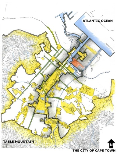 PLACES of CIVIC HYDROLOGY |
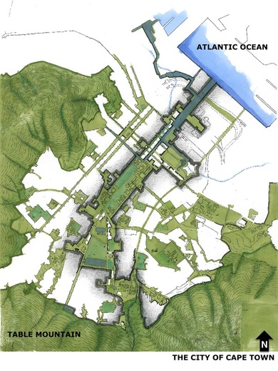 WEB of SOCIO-ECOLOGICAL LINKS |
Maps by Caron von Zeil.
PUBLIC STRUCTURE LINKED BY CIVIC-HYDROLOGY
BUSINESS CASE RATIONALE
The approach brings real transformation highlights, challenging the narrow technological approach to addressing the sustainability issues of central Cape Town. Communities will be enabled to work with nature’s design principles being able to value their own richness and that of their environment; communities will experience projects that demonstrate the wealth of opportunities; and that working with true diversity can generate livelihood for all. True diversity thus allows each one to appreciate his or her uniqueness, whilst celebrating the inter-connectedness of all. With the backing of scientific knowledge this paves the way for real development to take place within the community, eco-system and the broader living environment.
Viewing economic growth in the narrow, physical, and consumptive sense, rather than in a broader qualitative sense, which allows for adding value beyond physical limits is a chief consideration of this programme.
The following sections (1-8) are a brief introduction to concepts and the motivation for reclaiming CAMISSA:
1 - WATER: THE DRIVER OF NATURE AND SETTLEMENT
Water is in and of itself an economic resource and a scarce one at that. Capturing the water will help reduce the pressure on our water resources. By harnessing the power of the natural gravity fed system, it is possible to would generate enough power to lighting for the public spaces of the central city.
Water is also an important magnet for social activities and reclaiming CAMISSA provides a catalyst programme to renew the city centre as a social and economic space.
Opening of the historical waterways will provide opportunities for different types of economic activity and new economic developments which will assist in expanding the economic base, creating opportunities in and of itself for emerging entrepreneurs, engineers and others; and provide opportunities for skills training. In the renewal and maintenance of the system, employment would be created. And its rehabilitation would enhance the tourism value of the city, providing a link between the mountain and the sea, both established tourism attractions.
The programme will give rise to other developments (e.g. mixed use and higher density living areas) on the edges of the public landscapes, this densification made possible through the improved resource management. This will increase property values, particularly along the commercial edges allowing for higher rates and taxes.
The social capital potential is to fully develop the skills of all sectors of the community; and allow for public integration and education, via the recreational value of the system. The usage of the resource as a public amenity and the reclamation of this cultural landscape will enable the legibility the city deserves, whilst assisting social transformation.
2 - RETURN ON INVESTMENT IN PUBLIC INFRASTRUCTURE
REINVENTING AND RECLAIMING PUBLIC SPACE
The City of Cape Town initiated a process to formulate eight district spatial development frameworks – one for each of the City’s Planning Districts. The purpose of the District Plans is to provide medium term guidance to the spatial development of each of the 8 planning districts, in order to facilitate sound infrastructure investment and consideration of development applications. A further purpose of the District Planning process is to rationalise the spatial planning policy environment of the city of Cape Town. It is the intention that the plans will be approved as structure plans under the Land Use Planning Ordinance (LUPO), Ordinance 15 of 1985 and provide spatial direction and guidance to the City’s Integrated Development Plan.
There is no doubt that CAMISSA, as well as any other city-wide planning with respect to water must feature prominently in the Spatial Frameworks, District Planning and Integrated Development Planning exercises that drive urban renewal and public investment. Ideally the City’s Spatial Development Framework should be structured by water and associated land systems. The district planning should ideally have the water systems as foundational layers for land planning in general and for restructuring of existing spatial systems.
The District Plans are still underway and no specific proposals have been made to date that truly address sustainability and the issues of environment and ecology, thus leaving a fair opportunity for water as a fundamental planning informant. The intention is to affect the District Plans, in order to draft the spatial extent of CAMISSA into the plans for the central city to enable a review of land use planning opportunities in terms of possible integrated zoning, or reviewing the land that impacts the CAMISSA system to allow for appropriate zoning, development rights or allocation of land parcels associated with the system. This will further determine different City of Cape Town (CoCT) departments that will take responsibility for long-term maintenance and monitoring, unless there is a separate department set up e.g. ‘water’.
Drawing by Paul Andrew, Architect and Artist.
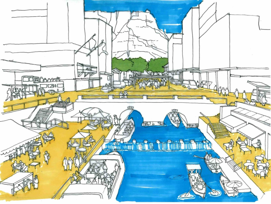
INTEGRATED TRANSPORTATION AND INFRASTRUCTURE
An Illustration of the intersection between NEW WATERSEDGE and THE OLD CITY WATERWAYS. Looking up the Heerengracht (in foreground) with Adderley Street's subterranean twin gracht intersecting below Strand Street (centre of the illustration) and the Company's Gardens in the background.
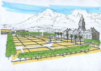
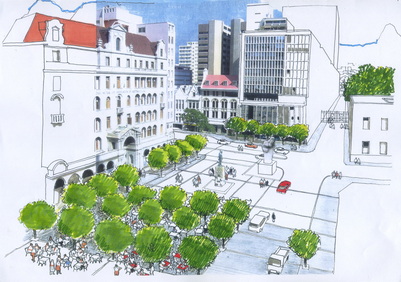
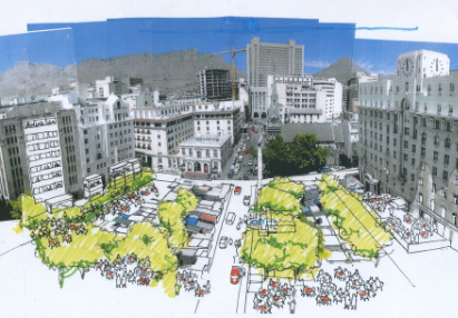
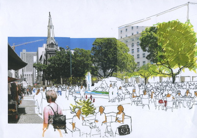
3rd PRECINCT: THE GRAND PARADE
|
3rd PRECINCT: CHURCH SQUARE
|
3rd PRECINCT: GREENMARKET SQUARE
|
3rd PRECINCT: GREENMARKET SQUARE
|
Drawings by Paul Andrew, Architect and Artist.
THE CITY'S PUBLIC SQUARES - LINKED BY WATER
3 - ECOLOGICAL SERVICES AND RENEWABLE ENERGY
The opportunities for ecological services and process engineering, such as re-instating the slow sand filter and the mills, re-introducing wetlands and bio-diversity; and the irrigation of street trees and urban landscaping are plentiful. Concepts of ecological services (i.e. “free services” provided by nature - reed beds, etc.) and the potential payment for ecological services together with aspects of process engineering are value added assets.
As examples:
A considerable asset to the central city, would be the provision of renewable (clean) energy through interventions with water wheels and turbines that will provide for the lighting of the public spaces.
RECLAIM CAMISSA has already achieved this at the Green Point Eco-Park, see here.
And hopes to achieve this at the FIELD OF SPRINGS and the TWISTNIET FIELD.
As examples:
- Five of the springs, was a substantial supply. In the year 1896-1897, 811 000 000 imperial gallons of water (364 950 000 litres) were run off. The elevation at which the water was stored made it very valuable for hydraulic power. Thomas Stewart in 1897, recorded that an effective 750 horse power was obtained for every 12 hours of every day, throughout the whole year.
- Graaff's Hydro-Electric, supplied Cape Town with electricity for street lights, whilst most of London still operated gas lamps, in 1895. See also here and here.
A considerable asset to the central city, would be the provision of renewable (clean) energy through interventions with water wheels and turbines that will provide for the lighting of the public spaces.
RECLAIM CAMISSA has already achieved this at the Green Point Eco-Park, see here.
And hopes to achieve this at the FIELD OF SPRINGS and the TWISTNIET FIELD.
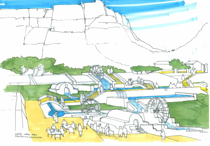
Drawing by Paul Andrew, Architect and Artist.
POWERED BY WATER
4 - SUSTAINABLE WATER MANAGEMENT
QUANTUM LEVEL APPLICATION
By applying the thesis of WATER AS A FLUX: Q x F = Y by Prof. Anthony Turton, as the basis for the implementation of the proposed environmental framework centered on civic hydrology, CAMISSA becomes a model to validate the thesis; and therefore provides solutions for application at a quantum level scale, as it would benefit places and people globally.
In water-constrained economies, this simple equation can be used to demonstrate how to best unlock the full potential from the total available stock of water, expressed as follows:
- Q = is the stock value of water, expressed as the volume (flow) of the total national water resource that is available at a high assurance of supply level at any one time.
- F = is the multiplier value of water as a flux, the value derived from reuse i.e. by water wheels.
- Y = the total water supply needed at a high assurance of supply to sustain the desired economic development potential at any moment in time.
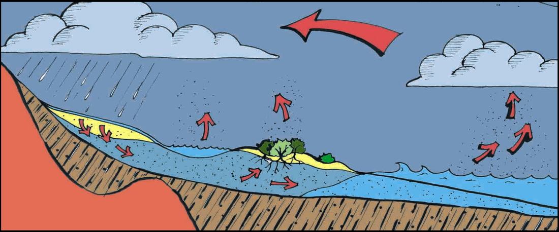
The Hydrological Cycle
Drawing by Ryan Lambert and Caron von Zeil.
"The national economy is a wholly owned subsidiary of the national ecology" - Prof. Tony Allan, Stockholm Laureate of Water
5 - URBAN RE-STRUCTURING; RENEWAL AND DENSIFICATION
Unique to Cape Town is the abundance of open land - virtually a greenfield site, within the inner city. Served by an ease of vehicular access; abundant potential for parking provision in new buildings; views of the bay and the mountain. Due to the reclaimed resources, densification is made possible along the edges of Camissa, especially in the Foreshore, Culembourg and District Six neighbourhoods. This would assist in addressing the current 'sprawl city' model. These areas should be developed within the ambit of environmental principles, sustainability and equality, thus reducing the need for expansive utility infrastructure and service delivery. Mixed-use development for low and middle-income groups is proposed, as people living close to places of work reduces the dependency on the motor vehicle, commuter travel time, and parking issues within the inner city and costs.
By re-structuring the urban fabric of the city according to environmental principles and securing the central city's resource, CAMISSA functions as a catalyst for urban renewal, economic generation and development. This would allow for mixed-use densification within the central city along the edges, made possible through improved resource management.
Thus, allowing for new neighbourhoods - as illustrated below, where the development and densification of middle/low income mixed-use accommodation is possible, in the Foreshore, Culembourg and District Six - allowing for waterways to mitigate against sea surges and sea level rise.

An illustration of new typologies for mixed-use neighbourhoods - the Foreshore, Culembourg and District Six - allowing for sea water passage as a means to mitigate against sea surges and sea level rise. Hence, the city would be densified, providing better surveillance and making it a safer city; and allowing for people to live closer to their places of work; reducing infrastructural costs and the dependency on cars and public transport.
Drawing by Paul Andrew, Architect and Artist.
LIVING WATER = LIVING CITY
6 - CIVIC PROCESS OF REDISCOVERY
HERITAGE RECLAMATION & CULTURAL RESTORATION
The reclamation and restitution of the environmental and cultural heritage of this system not only provides the structure of the public realm of the city - it is the very reason and meaning, reflecting the rich and diverse public heritage. The renewal of this cultural landscape provides lessons in history and cultural education through the process of rediscovery. In revealing the layers of the heritage landscape; memory; spiritual significances; hidden or forgotten heritage; women’s experience of the environment; the linkages between the mountain and the sea; and the reclamation of the heritage engineering and infrastructure adds value beyond the physical limits of the programme. One of many aspects of these qualitative attributes is the ability that is offered in terms of citizens being able to integrate through their recreational use of the system and emerge with a more united public image, through place making.
The reclamation and restitution of the environmental and cultural heritage of this system not only provides the structure of the public realm of the city - it is the very reason and meaning, reflecting the rich and diverse public heritage. The renewal of this cultural landscape provides lessons in history and cultural education through the process of rediscovery. In revealing the layers of the heritage landscape; memory; spiritual significances; hidden or forgotten heritage; women’s experience of the environment; the linkages between the mountain and the sea; and the reclamation of the heritage engineering and infrastructure adds value beyond the physical limits of the programme. One of many aspects of these qualitative attributes is the ability that is offered in terms of citizens being able to integrate through their recreational use of the system and emerge with a more united public image, through place making.
7 - CO-OPERATIVE INSTITUTIONAL AND CIVIC MANDATES
A programmatic partnership approach is necessary as currently public land is the most difficult to develop - this should not be the case. Institutional mandates for water use and management, service provision, heritage management, conservation, and investment in urban renewal requires more co-operative collaboration and the integration of such.
RECLAIM CAMISSA's Steering Committee will direct the design process by providing guidelines for other teams to address the individual precincts, projects and products. The design of “bite size chunks”, according to the phasing of the programme and the implementation of these would be co-ordinated by RECLAIM CAMISSA, facilitated through public competitions, in partnership with others and integrated with PGWC and COCT. These works would be executed through the collaboration of various teams (consortiums of Urban Designers; Planners; Landscape Architects; Architects; Engineers; Designers; and Artists) together with institutions; organisations; civic groups and the public - working together. Through implementation, each project would provide for community development, employment and skills training.
RECLAIM CAMISSA's Steering Committee will direct the design process by providing guidelines for other teams to address the individual precincts, projects and products. The design of “bite size chunks”, according to the phasing of the programme and the implementation of these would be co-ordinated by RECLAIM CAMISSA, facilitated through public competitions, in partnership with others and integrated with PGWC and COCT. These works would be executed through the collaboration of various teams (consortiums of Urban Designers; Planners; Landscape Architects; Architects; Engineers; Designers; and Artists) together with institutions; organisations; civic groups and the public - working together. Through implementation, each project would provide for community development, employment and skills training.
8 URBAN ECO-TOURISM
CAMISSA is sited between two World Heritage and eco-tourism sites
- Table Mountain and Robben Island; and is of national importance as the
frontier of our modern state. Cape Town has also been crowned Africa's
leading destination with the prestigious World Travel Award, in the global travel industry.
As the Council for Geosciences has estimated, each foreign
tourist who visits South Africa creates eight permanent jobs - tourism is therefore
critical to the economy of the country. Eco-tourism has not been tapped into in
South Africa. The potential of Urban Eco-tourism as a strategy is further
discussed under the Development
Strategies, with particular regard for the various treatments of a Cultural Landscape.
As per the Mexican examples of 'community urban-eco tourism', projects that could already emerge under this umbrella are walking trails; guided tours and archaeological dig sites, etc. Where locals partake, and tourists pay to be involved in the 'dig', under the guidance of Archaeologists, experts and trained people.
As per the Mexican examples of 'community urban-eco tourism', projects that could already emerge under this umbrella are walking trails; guided tours and archaeological dig sites, etc. Where locals partake, and tourists pay to be involved in the 'dig', under the guidance of Archaeologists, experts and trained people.
THE SPATIAL CONCEPT
What follows is a brief description of the overall spatial concept, derived from the rationale previously described and with due consideration to further research and development required by the phased programme. Water and land - an inseparable combination, are not only indispensable to human survival, but intrinsic to human and other living species’ quality of existence. How those who work in natural and built landscapes make water and land work together in unison is a key consideration in the conceptualisation of how one approaches the reclamation of Camissa, among other water and land systems in Cape Town.
To conceptualise Camissa from a spatial perspective it is necessary to examine the whole of which Camissa is but one part. What this means, is that Camissa is a sub-system of a regional water and land system that finds expression in space in the landscape of Cape Town, and far beyond the boundaries of this city. It is common knowledge that water and land are infinitely linked across boundaries throughout the world thus must be approached from a systemic point of view. The first principle therefore adopted by the spatial team is that of a unified urban system.
This approach is based on ‘respect for water and land’ as a structuring element for urban development and restructuring the urban landscape within a natural framework that is also comprised of other ecological considerations that associate directly with water and land. In revealing the intrinsic value of water and land to society and those who manage public assets, emphasis would be placed on their scarcity and therefore sustainability rather than their economic value alone, which is why Camissa and other systems have been trapped in the modernisation and commoditisation of particularly land, in Cape Town.
To ground the project in day-to-day physical realities, it is important to research and map water, land and natural systems throughout the greater metropolitan Cape Town area; and their relationships to the city’s edges and hinterland. In this way, the role of each system can be unveiled and revealed through a series of uncoverings that would come not only from the research team but also from the communities who inhabit the lands where the water systems run. While some of this work is available from secondary sources of information, they have not been analysed and interpreted from a systemic viewpoint and understanding their role in (re) structuring society and urban development to ensure sustainability. Qualitative (role and value) and quantitative information (volumes and flows) would be prepared and presented in different layers covering:
Water systems: sea, natural springs and water sources, water bodies, river systems, aquifer, water that is channelled underground (such as the Platteklip and Camissa) etc. It is important to note that there are numerous different water systems in Cape Town and these systems need to be understood in terms of their functions, possibilities and relationship to the metropolitan area.
Land systems: land information relative to water courses including landscape elements, mountain ranges, built form, land use, zoning, bulk storm water infrastructure and channels, bulk waste water infrastructure and bulk potable water infrastructure etc.
The intention is that once Camissa has been contextualised at the scale of the city, in this way - the system would be unpacked at the detailed scale, to begin to inform the precinct planning.
Drawing by Caron von Zeil.
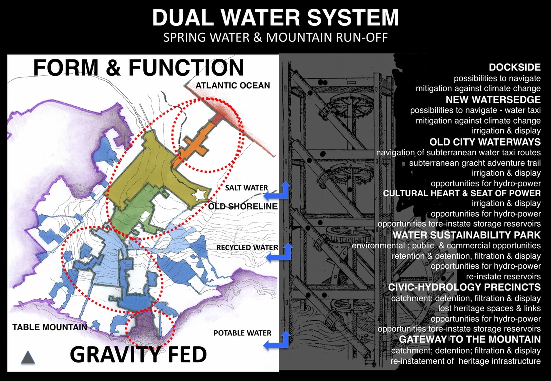
HYDROLOGICAL FRAMEWORK STRUCTURE: FORM AND FUNCTION
PRECINCTS
These "precincts" have been defined after spatially mapping the geographical area from the perspective of 'a city within its region'; and the local area within the metropolitan area, in accordance with its natural systems; urban systems; transportation routes; public amenities; economic generators; building typologies - and then overlayed with a series of maps that examine how the city functions for its inhabitants and visitors, on a temporal spatial basis - i.e throughout the different seasons of Winter, Spring, Summer and Autumn - day or night.
What becomes evident, after many analysis maps, is this:
There are seven distinct areas within the city bowl, that reflect the fundamental reason for the city's establishment - the ways in which water occurs; functioned previously; and could potentially function in the future of the city - if environmental principles are applied; and if we are to reclaim and use the water resources and their associated land parcels, to the benefit of the city and her inhabitants, optimally.
Within each of these 7 PRECINCTS are numerous options for project proposals - which you will soon be able to find on these pages meanwhile, look here to see the geographical outline of these area.
RECLAIM CAMISSA PROGRAMME
By implementing a cascading economic model that facilitates implementation in the 7th Precinct down to the 1st Precinct, with the resource and economic gains of one precinct being used to facilitate the development of the precincts lower down. Commencing with the most important aspect - that of securing the water resources at their source.
PURPOSE
In 22 years the programme would have achieved:
DEVELOPMENT INDICATORS FOR THE PROGRAMME
The following indicators represent the high level outcomes, as a measurement for achievement of the programme. The main aspect, being that of the bigger picture - sustainability in terms of CITY/REGION issues:
OUTCOMES - THE SYSTEM PROVIDES THE FOLLOWING
In terms of SUSTAINABILTY:
In terms of URBAN MOBILITY:
In terms of PLACE and CULTURAL IDENTITY:
Why invest in the city bowl, especially since it would seem that any monies for development should be spent in the poorer areas of the Cape Flats? The site lies between two World Heritage sites - Table Mountain and Robben Island, and is of national importance as the frontier of our modern state. This water allowed for global trade routes and thus the very raison d’être for settlement at the Cape. These waters are the key to understanding and appreciating the natural history, the social and cultural history and the very meaning of settlement of the Mother City.
“....the city bowl has historical and symbolic significance regionally and nationally making it unique in its potential to redress past inequalities in access to facilities, amenities and housing. Effective management of the assets that the city bowl represents will greatly assist the reallocation of public resources to less developed areas outside the city bowl. The benefits from an effectively managed city bowl can be used to assist in the development of these areas to achieve equity.” -- Cape Town’s City Bowl Development Area, 1997:5.
In terms of PUBLIC EDUCATION:
Whilst the system as a whole will function to publically educate through civic hydrology, and thus function as an open-air museum, there are added opportunities:
In terms of (OTHER) ECONOMIC GENERATORS:
PHASED 22 YEAR PROGRAMME
PHASE ONE: 1 year: 2008 - 2009
PHASE TWO: 4 years: 2010 - 2014
PHASE FOUR: 3 years: 2016 - 2019
PHASE FIVE: 2 years: 2019 - 2021
PHASE SIX: 3 years: 2021 - 2024
PHASE SEVEN: 2 years: 2024 - 2026
PHASE EIGHT: 2 years: 2026 - 2028
PHASE NINE: 3 years: 2028 - 2030
PURPOSE
In 22 years the programme would have achieved:
- securing the water, currently scrapped from the asset resource register of the city. This includes the mountain run-off from the Platteklip Stream and water from as many of the city's thirty-six artesian springs, as deemed possible - for the benefit of all.
- the improvement of the public spaces associated with the water system of the central city - thus reclaiming the city's heritage and very meaning.
- improved utilisation of public space to enhance the cultural identity of the city.
- a pedestrian and bicycle dominated central spine, which integrates the infrastructural system taking advantage of opportunities for water navigation and ecological services.
- assisting in providing the environmental and resource security, necessary to restructure the city, thereby allowing for densification and development of under utilised land along the edges.
DEVELOPMENT INDICATORS FOR THE PROGRAMME
The following indicators represent the high level outcomes, as a measurement for achievement of the programme. The main aspect, being that of the bigger picture - sustainability in terms of CITY/REGION issues:
- resources secured and used differently
- water
- waste
- energy
- bio-diversity
- cultural heritage
- restructuring of the city according to environmental principles
- place making through the environmental and cultural uniqueness of the place
- united public identity
- public environmental education
- social capital: jobs created and skills training provided
- improved property values, leading to higher rates and taxes to the benefit of the city
OUTCOMES - THE SYSTEM PROVIDES THE FOLLOWING
In terms of SUSTAINABILTY:
- catchment of mountain run-off; storm water and spring water by making use of the natural dual water system.
- rehabilitation of as many of the artesian springs for potable use.
- a variety of different models of detention; retention; natural filtration and purification processes for water.
- implementation of ecological connections that demonstrate naturalistic approaches to park design with diverse plant species and wildlife habitats throughout the system.
- rehabilitation of the old (slow) sand filtration plant.
- generation of energy through reinstating some of the old mills (water wheels) to generate energy.
- generation of energy through re-inventing Graaff’s hydro–electric as an exhibition and resource space to explore alternative energy.
- water storage through re-instating existing subterranean reservoirs.
- creation of a 'Water Sustainability Park' – providing public environmental education, through the interactive engagement with various water concepts; models for new bio technologies, installations; public art and information. An educational experience, with compelling permanent and temporary exhibits; and educational programmes focused on demonstrating the how, what and why of water.
- provide the water required for irrigation of city landscaping; water features and fountain displays through the grey water system.
- re-instate the lei-water system of the Company Garden's for irrigation.
- provide public drinking fountains throughout the system via the spring water - in the hope that the city can follow with a civic campaign to prohibit bottled water, within the inner city.
- allows for the edges of CAMISSA to be densified with new mixed-use accommodation, due to the reclamation of the resources.
- economic generation; job creation and skills training.
- community food gardens.
In terms of URBAN MOBILITY:
- Pedestrian and bicycle dominance throughout the central spine.
- Opening of a navigable Heerengracht with canal connections from the V & A Waterfront to CTICC, to the station and the castle moat connection; as a means to mitigate against sea surges and sea level rise. A new Heerengracht jetty / main dock connected to the existing transportation hub, providing infrastructure to decrease the carbon footprint and dependency on fossil fuel; and to improve possibilities for water connections from other GCTMAs e.g Tableview, Khayelitsha, Monwabisi, Muizemberg, etc. In this way, allowing the city to be more accessible and integrated.
- Increased opportunities for water taxi routes to the Company Gardens, via the subterranean navigable twin gracht below Adderley Street to the Company Gardens; and elsewhere.
- Subterranean Tunnel walks to be established as adventure trails and tourist attractions, through a social capital project to empower youth at risk.
In terms of PLACE and CULTURAL IDENTITY:
Why invest in the city bowl, especially since it would seem that any monies for development should be spent in the poorer areas of the Cape Flats? The site lies between two World Heritage sites - Table Mountain and Robben Island, and is of national importance as the frontier of our modern state. This water allowed for global trade routes and thus the very raison d’être for settlement at the Cape. These waters are the key to understanding and appreciating the natural history, the social and cultural history and the very meaning of settlement of the Mother City.
“....the city bowl has historical and symbolic significance regionally and nationally making it unique in its potential to redress past inequalities in access to facilities, amenities and housing. Effective management of the assets that the city bowl represents will greatly assist the reallocation of public resources to less developed areas outside the city bowl. The benefits from an effectively managed city bowl can be used to assist in the development of these areas to achieve equity.” -- Cape Town’s City Bowl Development Area, 1997:5.
- Heritage exposure to include interpretative signage, way finders, etc.
- Proliferation of heritage infrastructure and past places associated with the hydrological system, allow for smaller east-west connections across the city's precincts, to link public amenities.
- Cultural water history museum.
- Art Platforms for exhibitions, outdoor art works and performances at selected sites.
In terms of PUBLIC EDUCATION:
Whilst the system as a whole will function to publically educate through civic hydrology, and thus function as an open-air museum, there are added opportunities:
- Tours along the historical watercourses of Cape Town, by means of maps, information and way finders.
- Tours operated through the tunnels of Cape Town.
- Demarcated areas to allow for information boards, way finders, signage and interactive demonstration models, public workshops and events.
- Specific sites with multi-functional water and cultural museums, to enable the show casing of Cape Town's history with regard to water - to include interactive public education.
- Adventure trails and children's safe play parks - to include interactive waterplay.
- Demarcated events areas, including multi-functional surfaces for erecting marquees on open, flat, grassed areas for play, performance and events.
In terms of (OTHER) ECONOMIC GENERATORS:
- Open Markets.
- Opportunities for mixed-use densification.
- Commercial opportunities at pedestrian level along the edges.
- Any many more, including job creation and skills training.
PHASED 22 YEAR PROGRAMME
PHASE ONE: 1 year: 2008 - 2009
- Continued research into precedent studies, precinct analyses and design, collaboration and advocacy.
- Founding Documentation.
- Programme Concept Documentation.
- Budget requirements for the organisational running costs.
- Data Collection.
- Strategies and Development of projects.
PHASE TWO: 4 years: 2010 - 2014
- Registration of Public Benefit Organisation (PBO) with 18A tax exempt status.
- Establishment of partnership agreements and MOUs, to include institutional roles within the process.
- Establishment of 'The Friends of CAMISSA'.
- SEED FUNDING to cover:
- Organisational running costs
- Mechanisms in place to record quantitative and qualitative data.
- Programme Development, Design Development and Guidelines, by Members of the Working Group.
- Feasibility and Time Scale Programme Projection, by Members of the Working Group.
- Business Plan for the KEY PROJECT: 'Field of Springs' Project, by Members of the Working Group.
- Design Development for the 'Field of Springs' Project, by Members of the Working Group.
- Planning Approval stage for the 'Field of Springs' Project, by Members of the Working Group.
- LAUNCH EVENT: 'RECLAIM THE SWEET WATERS WALK'
- Funding and Implementation of KEY PROJECT: 'The Field of Springs'.
- Operational maintenance and management structures established through social development for 'The Field of Springs'.
- Continued research, data collection and design development of system.
- Establishment of annual RECLAIM CAMISSA public event.
- Design Guidelines established for 7th Precinct project designs, by Members of the Working Group.
- Public competitions for 7th Precinct project designs, through collaboration between a variety of disciplines and civic groups.
- 7th Precinct project design competitions awarded.
- Procurement of funding for implementation of 7th Precinct project design competition winners.
- Continued social capital and skills development projects.
PHASE FOUR: 3 years: 2016 - 2019
- Funding and Implementation of 7th Precinct project designs.
- Operational maintenance and management structures established through social development for 7th Precinct projects.
- Continued research, data collection and design development of system.
- Design Guidelines established for 6th Precinct project designs, by Members of the Working Group.
- Public competitions for 6th Precinct project designs, through collaboration between a variety of disciplines and civic groups.
- 6th Precinct project design competitions awarded.
- Procurement of funding for implementation of 6th Precinct project design competition winners.
- Design Guidelines established for spring water drinking fountains, throughout the city bowl, by Members of the Working Group.
- Public competitions for spring water drinking fountain designs, through collaboration between a variety of disciplines and civic groups.
- Spring water drinking fountain project competitions awarded.
- Procurement of funding for implementation of spring water drinking fountain design project competition winners.
- Continued social capital and skills development projects.
PHASE FIVE: 2 years: 2019 - 2021
- Funding and Implementation of 6th Precinct project designs.
- Operational maintenance and management structures established through social development for 6th Precinct projects.
- Continued research, data collection and design development of system.
- Design Guidelines established for 5th Precinct project designs, by Members of the Working Group.
- Public competitions for 5th Precinct project designs, through collaboration between a variety of disciplines and civic groups.
- 5th Precinct project design competitions awarded.
- Procurement of funding for implementation of 5th Precinct project design competition winners.
- Design Guidelines established for spring water drinking fountains, throughout the city bowl, by Members of the Working Group.
- Public competitions for spring water drinking fountain design projects, through collaboration between a variety of disciplines and civic groups.
- Spring water drinking fountain project competitions awarded.
- Procurement of funding for implementation of spring water drinking fountain project competition winners.
- Implementation of upper (inner city edge) spring water drinking fountain projects.
- Continued social capital and skills development projects.
PHASE SIX: 3 years: 2021 - 2024
- Funding and Implementation of 5th Precinct project designs.
- Operational maintenance and management structures established through social development for 5th Precinct projects.
- Continued research, data collection and design development of system.
- Design Guidelines established for 4th Precinct project designs, by Members of the Working Group.
- Public competitions for 4th Precinct project designs, through collaboration between a variety of disciplines and civic groups.
- 4th Precinct project design competitions awarded.
- Procurement of funding for implementation of 4th Precinct project design competition winners.
- Ongoing procurement of funding for implementation of spring water drinking fountain projects.
- Ongoing implementation of inner city (CBD) spring water drinking fountain projects.
- Continued social capital and skills development projects.
PHASE SEVEN: 2 years: 2024 - 2026
- Funding and Implementation of 4th Precinct project designs.
- Operational maintenance and management structures established through social development for 4th Precinct projects.
- Continued research, data collection and design development of system.
- Design Guidelines established for 3rd Precinct project designs, by Members of the Working Group.
- Public competitions for 3rd Precinct project designs, through collaboration between a variety of disciplines and civic groups.
- 3rd Precinct project design competitions awarded.
- Procurement of funding for implementation of 3rd Precinct project design competition winners.
- Continued social capital and skills development projects.
PHASE EIGHT: 2 years: 2026 - 2028
- Funding and Implementation of 3rd Precinct project designs.
- Operational maintenance and management structures established through social development for 3rd Precinct projects.
- Continued research, data collection and design development of system.
- Design Guidelines established for 1st and 2nd Precinct project designs, by Members of the Working Group.
- Public competitions for 1st and 2nd Precinct project designs, through collaboration between a variety of disciplines and civic groups.
- 1st and 2nd Precinct project design competitions awarded.
- Procurement of funding for implementation of 1st and 2nd Precinct project design competition winners.
- Continued social capital and skills development projects.
PHASE NINE: 3 years: 2028 - 2030
- Funding and Implementation of 1st and 2nd Precinct project designs.
- Operational maintenance and management structures established through social development for 1st and 2nd Precinct projects.
- Ongoing procurement of funding for implementation of 1st and 2nd Precinct projects.
- Implementation of 1st and 2nd Precinct projects.
- Continued social capital and skills development projects.
|

|
|
|
© COPYRIGHT
ALL RIGHTS ARE RESERVED by THE RECLAIM CAMISSA TRUST No. IT 2882/2010.
The use of material on this page is permitted with acknowledgement of the source and prior written consent - contactable via [email protected]
All research, spatial framework and proposals are the intellectual property of Caron von Zeil.
